IMAGES TAKEN NEAR TO
Spire View, SALISBURY, SP4 6DP
Introduction
This page details the photographs taken nearby to Spire View, SP4 6DP by members of the Geograph project.
The Geograph project started in 2005 with the aim of publishing, organising and preserving representative images for every square kilometre of Great Britain, Ireland and the Isle of Man.

There are currently over 7.5m images from over14,400 individuals and you can help contribute to the project by visiting https://www.geograph.org.uk
Image Map
Images are licensed for reuse under creativecommons.org/licenses/by-sa/2.0
Notes
- Clicking on the map will re-center to the selected point.
- The higher the marker number, the further away the image location is from the centre of the postcode.
Image Listing (13 Images Found)
Images are licensed for reuse under creativecommons.org/licenses/by-sa/2.0
Image
Details
Distance
1
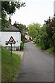
Entering Ford village from the A338
The river Bourne flows through the village and doubtless accounts for the ducks.
Image: © Peter Facey
Taken: 21 Jun 2006
0.06 miles
2
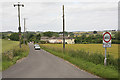
Road leading to Ford village from A338
A338 and railway bridge behind photographer. All properties visible in picture are part of Ford village.
Image: © Peter Facey
Taken: 21 Jun 2006
0.10 miles
3
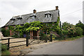
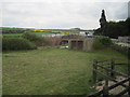
Ford Mill, Ford, nr Salisbury
Set on the Bourne river, a stone in the righthand gable says 1783.
Image: © Peter Facey
Taken: 21 Jun 2006
0.12 miles
4

Ford, watermill
Once using the power from River Bourne.
Image: © Mike Faherty
Taken: 11 Sep 2011
0.13 miles
5
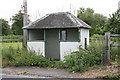
Forlorn bus shelter on A338 near railway bridge.
It had a bang up to date timetable inside, no glass in windows, a collection of litter and an old pillow inside.
Image: © Peter Facey
Taken: 21 Jun 2006
0.14 miles
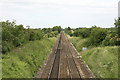
7
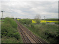
Andover Salisbury Railway line from A338 bridge
Image: © John Firth
Taken: 10 May 2010
0.16 miles
8
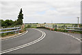
Bridge carrying A338 over Andover-Salisbury railway
This will be familiar to motorists. Travelling north, the A338 bends sharp left, goes over a narrow humped-back bridge, and then bends sharply right. The road at right is a minor road leading to the A30.
Image: © Peter Facey
Taken: 21 Jun 2006
0.17 miles
9
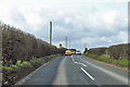
A338 towards Salisbury
Roundabout and narrow railway bridge ahead.
Image: © Robin Webster
Taken: 1 Apr 2018
0.20 miles
10
Salisbury-Andover railway lines seen from bridge over A338 near Ford village
Image: © Peter Facey
Taken: 21 Jun 2006
0.21 miles