1
A345 near Longhedge Farm
Image: © Julian P Guffogg
Taken: 12 Aug 2013
0.02 miles
2
Longhedge House
Image: © Anthony Parkes
Taken: 1 Jun 2023
0.04 miles
3
Builders' landscape
Site of future housing at Longhedge, north of Salisbury: currently something of a builders' wasteland.
Image: © David Martin
Taken: 17 Oct 2020
0.07 miles
4
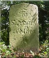
Milestone, A354
Beside the Salisbury to Amesbury Road near Longhedge Farm.
Image: © Maigheach-gheal
Taken: 26 Feb 2009
0.11 miles
5
New housing north of Salisbury
A greenfield development well out of town. The roundabout on the A345 is new.
Image: © Robin Webster
Taken: 16 Dec 2017
0.13 miles
6
Old Milestone by the A345, Amesbury Road, Laverstock Parish
Carved stone post by the A345, in parish of LAVERSTOCK (SALISBURY District), Amesbury Road; 100m South of Monarchs Way footpath, 200m North of Longhedge House, on deep verge next to ash tree, on East side of road. Salisbury Roman stone, erected by the Marlborough & Salisbury turnpike trust in the 19th century.
Inscription reads:- : To / Salifbury / III / Miles / T(o) / M(a)rlbro :
Carved benchmark right lower.
Grade II Listed. List Entry Number: 1284849
Milestone Society National ID: WI_MLSA24.
Image: © M Faherty
Taken: 11 Aug 2007
0.13 miles
7
Bridleway to Winterbourne Earls
The bridleway crosses the A354 on its way from the Woodford Valley at this point. It is also part of the Monarchs Way.
Image: © Maigheach-gheal
Taken: 26 Feb 2009
0.17 miles
8
Bridleway to Lower Woodford
The bridleway takes riders and walkers from Winterbourne Earls to the Woodford valley. This part of the bridleway is used as a section of the Monarchs Way. It has just crossed the A354.
Image: © Maigheach-gheal
Taken: 26 Feb 2009
0.18 miles
9
New housing in Nicolson Vale, Longhedge
Part of a substantial new housing development, still under construction.
Image: © David Martin
Taken: 17 Oct 2020
0.20 miles
10
Welcome to Phase 3
New housing development at Longhedge, north of Salisbury. Hopefully to gain a more endearing neighbourhood name, in time.
Image: © David Martin
Taken: 17 Oct 2020
0.20 miles


