IMAGES TAKEN NEAR TO
Salterton, SALISBURY, SP4 6AN
Introduction
This page details the photographs taken nearby to SP4 6AN by members of the Geograph project.
The Geograph project started in 2005 with the aim of publishing, organising and preserving representative images for every square kilometre of Great Britain, Ireland and the Isle of Man.

There are currently over 7.5m images from over14,400 individuals and you can help contribute to the project by visiting https://www.geograph.org.uk
Image Map
Images are licensed for reuse under creativecommons.org/licenses/by-sa/2.0
Notes
- Clicking on the map will re-center to the selected point.
- The higher the marker number, the further away the image location is from the centre of the postcode.
Image Listing (15 Images Found)
Images are licensed for reuse under creativecommons.org/licenses/by-sa/2.0
Image
Details
Distance
1
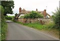
White Cottage
A thatshed house at Salterton, just above the Avon valley.
Image: © Derek Harper
Taken: 17 Jul 2016
0.00 miles
2
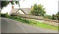
Salterton Knap
The thatched house is on a bend of the road from Netton. I like the varying coping along the wall - thatch, then tiles. Alas, the wall beneath the thatch is rather less interesting (presumably a restoration) than that beneath the tiles.
Image: © Derek Harper
Taken: 17 Jul 2016
0.07 miles
3
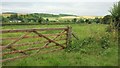
Field, Salterton
The view past the gate shown in Image I'm drawn to it by a distant burst of sunshine on this disappointingly gloomy morning walk. The houses on the left are at Middle Woodford, across the River Avon.
Image: © Derek Harper
Taken: 17 Jul 2016
0.09 miles
4
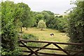
Cattle Pasture, Salterton
From a gateway on the right of the scene in Image], with a water channel flowing parallel to the River Avon on the far side.
Image: © Derek Harper
Taken: 17 Jul 2016
0.12 miles
5
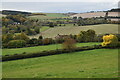
Avon Valley view from above Salterton Farm
Image: © David Martin
Taken: 17 Oct 2020
0.14 miles
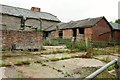
7
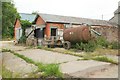
Salterton Farm
More farm buildings from the same spot on the Monarch's Way as Image
Image: © Derek Harper
Taken: 17 Jul 2016
0.14 miles
8
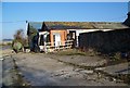
Salterton Farm
The farm is on the Monarch's Way.
Image: © Maigheach-gheal
Taken: 16 Feb 2008
0.16 miles
9
Salterton Farm
From the start of bridleway DURN 17, here carrying the Monarch's Way.
Image: © Derek Harper
Taken: 17 Jul 2016
0.16 miles
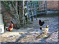
10
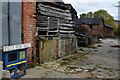
Eggs for sale
Amid derelict buildings at Salterton Farm. Interestingly, another Salterton Farm appears on the OS map on the opposite side of the valley.
Image: © David Martin
Taken: 17 Oct 2020
0.16 miles