IMAGES TAKEN NEAR TO
Little Durnford, SALISBURY, SP4 6AH
Introduction
This page details the photographs taken nearby to SP4 6AH by members of the Geograph project.
The Geograph project started in 2005 with the aim of publishing, organising and preserving representative images for every square kilometre of Great Britain, Ireland and the Isle of Man.

There are currently over 7.5m images from over14,400 individuals and you can help contribute to the project by visiting https://www.geograph.org.uk
Image Map
Images are licensed for reuse under creativecommons.org/licenses/by-sa/2.0
Notes
- Clicking on the map will re-center to the selected point.
- The higher the marker number, the further away the image location is from the centre of the postcode.
Image Listing (21 Images Found)
Images are licensed for reuse under creativecommons.org/licenses/by-sa/2.0
Image
Details
Distance
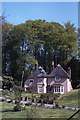
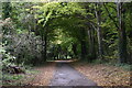
2
Beech Walk
Looking along Beech Walk past Little Durnford Manor, there is a benchmark at the base of the wall on the left (Image).
Image: © Jonathan Kington
Taken: 8 Dec 2011
0.08 miles
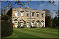
4
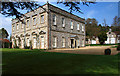
Little Durnford Manor House
Built in the late C17, the manor house at Little Durnford remained unaltered until remodelling took place in about 1720-40, and again towards the end of the C18.
The chequered stonework is of limestone and flint, with ashlar window surrounds. The house is Grade I Listed, and the stables to the right are Grade II.
Image: © Mike Searle
Taken: 20 Apr 2008
0.09 miles
5
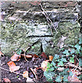
Benchmark, Little Durnford Manor
The cut mark is at the bottom of the roadside wall outside Little Durnford Manor, for a wider view see Image For more information on the benchmark visit http://www.bench-marks.org.uk/bm40478 .
Image: © Jonathan Kington
Taken: 8 Dec 2011
0.09 miles
6
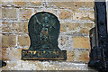
Old Fire Insurance plaque at Little Durnford Manor House
These metal plaques can often be seen on old buildings, and date from the time before the formation of municipal fire brigades. They were placed on fire insured buildings by the insurance company, to indicate the building was covered by their insurance.
Image: © Mike Searle
Taken: 20 Apr 2008
0.10 miles
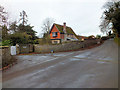
7
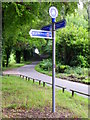
Sign post Little Durnford
National Route 45 of the National Cycle Network when finished, will connect Salisbury in Wiltshire with Chester in Cheshire, via Swindon, Cirencester, Gloucester, Worcester and Whitchurch.
Image: © Maigheach-gheal
Taken: 27 Jul 2011
0.10 miles
8
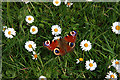
Peacock amongst the daisies - Little Durnford Manor House
Image: © Mike Searle
Taken: 20 Apr 2008
0.11 miles
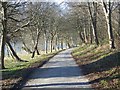
10
The Avenue approaching Little Durnford
Image: © David Martin
Taken: 17 Oct 2020
0.16 miles