IMAGES TAKEN NEAR TO
Allington, SALISBURY, SP4 0BP
Introduction
This page details the photographs taken nearby to SP4 0BP by members of the Geograph project.
The Geograph project started in 2005 with the aim of publishing, organising and preserving representative images for every square kilometre of Great Britain, Ireland and the Isle of Man.

There are currently over 7.5m images from over14,400 individuals and you can help contribute to the project by visiting https://www.geograph.org.uk
Image Map
Images are licensed for reuse under creativecommons.org/licenses/by-sa/2.0
Notes
- Clicking on the map will re-center to the selected point.
- The higher the marker number, the further away the image location is from the centre of the postcode.
Image Listing (22 Images Found)
Images are licensed for reuse under creativecommons.org/licenses/by-sa/2.0
Image
Details
Distance
1
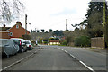
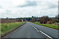
A338 through Allington
Heading towards Salisbury.
Image: © Robin Webster
Taken: 1 Apr 2018
0.01 miles
2
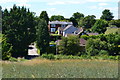
Houses on the northern edge of Allington
Image: © David Martin
Taken: 20 Jul 2020
0.06 miles
3
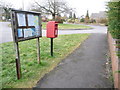
Allington: postbox № SP4 434, Wyndham Lane
This postbox and noticeboard stand at the corner of Wyndham Lane, with their backs to the main A338. Items need to be in the box by 4:15am on weekdays and by 9:30am on Saturdays to catch that day's post.
Image: © Chris Downer
Taken: 14 Feb 2009
0.11 miles
4
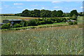
Fields beside the A338 north of Allington
Image: © David Martin
Taken: 20 Jul 2020
0.12 miles
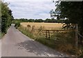
5

Headland path from Allington Track
The grassy headland to a field of wheat, followed by a footpath from Allington Track to the village.
Image: © Derek Harper
Taken: 2 Aug 2010
0.19 miles
6
A338 towards Salisbury
Approaching Allington.
Image: © Robin Webster
Taken: 1 Apr 2018
0.20 miles
7
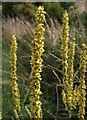
Mullein beside Allington Track
Verbascum nigrum (Dark mullein), I think, growing beside the road shown in Image
Image: © Derek Harper
Taken: 2 Aug 2010
0.20 miles
8
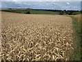
Wheatfield near Allington
Another view of Image from further south. Beacon Hill is left of centre on the skyline.
Image: © Derek Harper
Taken: 2 Aug 2010
0.22 miles
9
Road to Newton Tony
The road leaves Allington past a cornfield, gently ascending from the River Bourne.
Image: © Derek Harper
Taken: 2 Aug 2010
0.23 miles
10
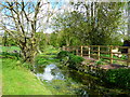
Allington - The River Bourne
The River Bourne meanders along.
Image: © Chris Talbot
Taken: 25 Apr 2009
0.23 miles