IMAGES TAKEN NEAR TO
West Tisbury, SALISBURY, SP3 6SW
Introduction
This page details the photographs taken nearby to SP3 6SW by members of the Geograph project.
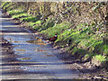
The Geograph project started in 2005 with the aim of publishing, organising and preserving representative images for every square kilometre of Great Britain, Ireland and the Isle of Man.

There are currently over 7.5m images from over14,400 individuals and you can help contribute to the project by visiting https://www.geograph.org.uk
Image Map
Images are licensed for reuse under creativecommons.org/licenses/by-sa/2.0
Notes
- Clicking on the map will re-center to the selected point.
- The higher the marker number, the further away the image location is from the centre of the postcode.
Image Listing (13 Images Found)
Images are licensed for reuse under creativecommons.org/licenses/by-sa/2.0
Image
Details
Distance
1
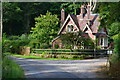
West Gate Lodge, on the Fonthill Abbey estate
Image: © David Martin
Taken: 12 Aug 2020
0.01 miles
2
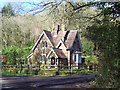
Cottage in White Mead Wood, Newtown
A cottage in the woods, all a bit Hansel and Gretel.
Image: © Maigheach-gheal
Taken: 9 Mar 2007
0.02 miles
3
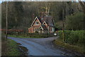
West Gate Lodge
On the minor forest road that runs northwards to Hindon.
I imagine this building guarded the western entrance to Fonthill Abbey at one time.
Image: © Chris Heaton
Taken: 11 Feb 2020
0.02 miles
4
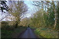
Entering the woods surrounding Beacon Hill
As it's getting late, we shortcut the Wessex Ridgeway path by taking this minor road straight to our overnight stop in Hindon.
Image: © Tim Heaton
Taken: 11 Feb 2020
0.06 miles
5
Cock pheasant near Beacon Hill
The Pheasant is the most familiar gamebird in Britain, often seen in the open on fields by roadsides. The spectacular male is better known than the brown, camouflaged female. Both have longer tails than any other ground-living British bird.
Image: © Maigheach-gheal
Taken: 9 Mar 2007
0.10 miles
6
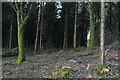
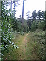
Beacon Hill 3
This path runs east close to the top and on the south side of Beacon Hill. The hill is 237 m high and is in the south-west corner of Fonthill Abbey Wood, see Image
Image: © Andy Gryce
Taken: 12 Jul 2007
0.18 miles
7
Mockeny Wood
Part of the large tract of woodland to the south of Hindon in Wiltshire
Image: © Chris Heaton
Taken: 11 Feb 2020
0.19 miles
8
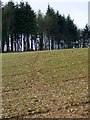
Footpath near Newtown
The footpath heads across the sown cereal field towards the minor road from Hindon to Newtown.
Image: © Maigheach-gheal
Taken: 10 Feb 2010
0.20 miles
9
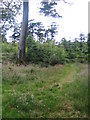
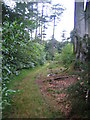
Beacon Hill
This path runs north close to the top and on the west side of Beacon Hill, which is 237 m high. Beacon Hill is heavily wooded and lies in the south-west corner of the Fonthill Abbey estate, and close to the unclassified north-south road from Hindon to Newtown. The hill is greensand which forms an escarpment around the hill and is an southerly extension of the greensand ridge which runs from Dinton in the east to East Knoyle in the east, a distance of 12km.
In 1796 on the north-east side of the woods, the eccentric and obsessive novelist William Beckford, built a romantic gothic folly, Fonthill Abbey, which subsequently collapsed, see Image Here is a print of the abbey which was painted from 'Beacon Terrace', which is possibly the east side of the hill, http://beckford.c18.net/rutterdelplate13.html.
Image: © Andy Gryce
Taken: 12 Jul 2007
0.21 miles
10
Beacon Hill 2
This path runs north close to the top and on the west side of Beacon Hill. The hill is 237 m high and is in the south-west corner of Fonthill Abbey Wood, see Image
Image: © Andy Gryce
Taken: 12 Jul 2007
0.21 miles