IMAGES TAKEN NEAR TO
Malthouse, SALISBURY, SP3 6NN
Introduction
This page details the photographs taken nearby to Malthouse, SP3 6NN by members of the Geograph project.
The Geograph project started in 2005 with the aim of publishing, organising and preserving representative images for every square kilometre of Great Britain, Ireland and the Isle of Man.

There are currently over 7.5m images from over14,400 individuals and you can help contribute to the project by visiting https://www.geograph.org.uk
Image Map
Images are licensed for reuse under creativecommons.org/licenses/by-sa/2.0
Notes
- Clicking on the map will re-center to the selected point.
- The higher the marker number, the further away the image location is from the centre of the postcode.
Image Listing (55 Images Found)
Images are licensed for reuse under creativecommons.org/licenses/by-sa/2.0
Image
Details
Distance
1
Housing, Tisbury
The modern brick built houses stand on the site of the Tisbury Workhouse.
Image: © Maigheach-gheal
Taken: 17 Sep 2009
0.03 miles
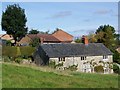
2
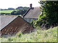
Wyck, Tisbury
Like Image, a view across the site of the medieval village of Wyck, built on a sloping platform above the Nadder valley in the background, which is crossed by the railway line from Yeovil. In the foreground a track leads to Wick Farm, built on the southeast side of the earthworks; the track just joining it on the extreme left leads to the other side of the same farm. http://www.heritagegateway.org.uk/Gateway/Results_Single.aspx?uid=210473&resourceID=2
Image: © Derek Harper
Taken: 9 Jul 2009
0.06 miles
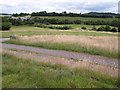
3
Wyck, Tisbury
The longer lighter grass on the left is growing on a slope of one of the earthworks of the medieval village of Wyck, now a deserted field crossed by tracks and a footpath and overlooking the Nadder valley on the southwest edge of Tisbury. The short terrace on the left is on Monmouth Road. The houses to its right are on High View Close.
Image: © Derek Harper
Taken: 9 Jul 2009
0.06 miles
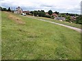
4
Wyck, Tisbury
This area of rough grass covers what remains of the lost Medieval village of Wyck.
Image: © Maigheach-gheal
Taken: 17 Sep 2009
0.09 miles
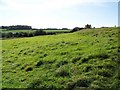
5
Wick Farmhouse, Tisbury
The house was built in the late 17th century of dressed limestone. It is said to stand on part of the lost Medieval village.
Image: © Maigheach-gheal
Taken: 17 Sep 2009
0.10 miles
6
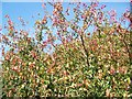
Spindle tree (Euonymus europaeus), Tisbury
Four thousands of years before the invention of the spinning wheel all the thread used for woollen cloth was spun by women twirling a stick called a spindle between their fingers. The spindle tree got its name because its thin stems came to be used for this purpose.
Image: © Maigheach-gheal
Taken: 17 Sep 2009
0.12 miles
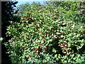
7
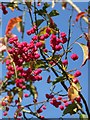
Spindle tree (Euonymus europaeus), Tisbury
After pollination the pistil ripens to the beautiful autumn fruit. This is a bright pink, four lobed capsule, which splits to reveal the bright orange flesh surrounding each hard yellow seed.
Image: © Maigheach-gheal
Taken: 17 Sep 2009
0.12 miles
8
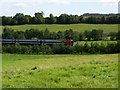
Train, Tisbury
The London to Exeter SouthWest train leaving Tisbury Station.
Image: © Maigheach-gheal
Taken: 17 Sep 2009
0.12 miles
9
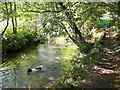
River Nadder, Tisbury
The dog swims in the river as we walk along Watery Lane.
Image: © Maigheach-gheal
Taken: 17 Sep 2009
0.12 miles
10
Guelder rose (Viburmum spulus), Tisbury
The leaves of this small shrub, sometimes called the snowball tree, are like those of the maple. They have three to five lobes and are set in pairs along the stems. Bright green in spring, they mellow to rich orange and russet in autumn, setting off the translucent scarlet berries. These, for all their ripe beauty, are bitter, but birds eat them.
Image: © Maigheach-gheal
Taken: 17 Sep 2009
0.12 miles