IMAGES TAKEN NEAR TO
Hindon, SALISBURY, SP3 6EG
Introduction
This page details the photographs taken nearby to SP3 6EG by members of the Geograph project.
The Geograph project started in 2005 with the aim of publishing, organising and preserving representative images for every square kilometre of Great Britain, Ireland and the Isle of Man.

There are currently over 7.5m images from over14,400 individuals and you can help contribute to the project by visiting https://www.geograph.org.uk
Image Map (Loading...)


Getting Data...Please wait
Leaflet Map data © OpenStreetMap
Images are licensed for reuse under creativecommons.org/licenses/by-sa/2.0
Notes
- Clicking on the map will re-center to the selected point.
- The higher the marker number, the further away the image location is from the centre of the postcode.
Image Listing (50 Images Found)
Images are licensed for reuse under creativecommons.org/licenses/by-sa/2.0
Image
Details
Distance
1
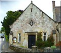
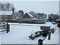
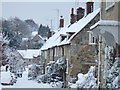
The Orange Way in Wiltshire (64)
This is the Village Hall in Hindon. The car is coming down Stops Hill. It's still raining. It is here that the Orange and Monarch's Ways meet up again.
To proceed to the next section of the Orange Way go to www.geograph.org.uk/geotrips/440.
Image: © Shazz
Taken: 26 Sep 2012
0.08 miles
2
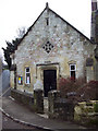
Hindon Village Hall
The village hall is at the bottom of the High Street.
Image: © Maigheach-gheal
Taken: 26 Dec 2006
0.08 miles
3
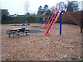
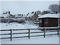
Playground
Children's play area at the bottom of Hindon High Street.
Image: © Maigheach-gheal
Taken: 26 Dec 2006
0.08 miles
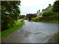
4
Hindon High Street
Look up the long wide High Street towards St John the Baptist Church.
Image: © Maigheach-gheal
Taken: 26 Dec 2006
0.08 miles
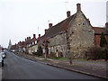
5
Looking up School Lane from The Dene, Hindon
Houses at the bottom of the High Street and view up School Lane from The Dene, Hindon
Image: © Hindonite
Taken: 6 Jan 2010
0.09 miles
6
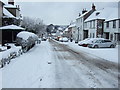
View down the High Street, Hindon
View down the High Street, Hindon, from outside the Lamb Inn. The Village Hall is visible at the bottom of the hill.
Image: © Hindonite
Taken: 6 Jan 2010
0.09 miles
7
The Orange Way in Wiltshire (63)
This is looking east along The Dene to the crossroads at the High Street.
Image: © Shazz
Taken: 26 Sep 2012
0.09 miles
8
Hindon playground and High Street
View from The Dene of Hindon playground and the High Street beyond.
Image: © Hindonite
Taken: 6 Jan 2010
0.09 miles
9
Looking down Hindon High Street from outside Baker's Arch
View down Hindon High Street from outside Baker's Arch.
Image: © Hindonite
Taken: 6 Jan 2010
0.09 miles
10
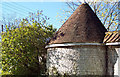
Squat Tower at Pinchers Hill, Hindon
Image: © Maigheach-gheal
Taken: 4 Oct 2004
0.10 miles