1
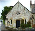
Hindon Village Hall
The village hall is at the bottom of the High Street.
Image: © Maigheach-gheal
Taken: 26 Dec 2006
0.05 miles
2
Playground
Children's play area at the bottom of Hindon High Street.
Image: © Maigheach-gheal
Taken: 26 Dec 2006
0.05 miles
3
Hindon High Street
Look up the long wide High Street towards St John the Baptist Church.
Image: © Maigheach-gheal
Taken: 26 Dec 2006
0.05 miles
4
Squat Tower at Pinchers Hill, Hindon
Image: © Maigheach-gheal
Taken: 4 Oct 2004
0.06 miles
5
Looking up School Lane from The Dene, Hindon
Houses at the bottom of the High Street and view up School Lane from The Dene, Hindon
Image: © Hindonite
Taken: 6 Jan 2010
0.06 miles
6
View down the High Street, Hindon
View down the High Street, Hindon, from outside the Lamb Inn. The Village Hall is visible at the bottom of the hill.
Image: © Hindonite
Taken: 6 Jan 2010
0.08 miles
7
The Orange Way in Wiltshire (63)
This is looking east along The Dene to the crossroads at the High Street.
Image: © Shazz
Taken: 26 Sep 2012
0.08 miles
8
The Orange Way in Wiltshire (64)
This is the Village Hall in Hindon. The car is coming down Stops Hill. It's still raining. It is here that the Orange and Monarch's Ways meet up again.
To proceed to the next section of the Orange Way go to www.geograph.org.uk/geotrips/440.
Image: © Shazz
Taken: 26 Sep 2012
0.08 miles
9
Looking down Hindon High Street from outside Baker's Arch
View down Hindon High Street from outside Baker's Arch.
Image: © Hindonite
Taken: 6 Jan 2010
0.08 miles
10
Brick houses on the northeast side of High Street, Hindon
Brick houses on the northeast side of Hindon High Street, just below the old Methodist Chapel.
Image: © Hindonite
Taken: 6 Jan 2010
0.09 miles


