IMAGES TAKEN NEAR TO
Hindon Road, SALISBURY, SP3 5TE
Introduction
This page details the photographs taken nearby to Hindon Road, SP3 5TE by members of the Geograph project.
The Geograph project started in 2005 with the aim of publishing, organising and preserving representative images for every square kilometre of Great Britain, Ireland and the Isle of Man.

There are currently over 7.5m images from over14,400 individuals and you can help contribute to the project by visiting https://www.geograph.org.uk
Image Map
Images are licensed for reuse under creativecommons.org/licenses/by-sa/2.0
Notes
- Clicking on the map will re-center to the selected point.
- The higher the marker number, the further away the image location is from the centre of the postcode.
Image Listing (33 Images Found)
Images are licensed for reuse under creativecommons.org/licenses/by-sa/2.0
Image
Details
Distance
1
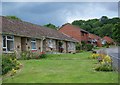
Spracklands, Dinton
An area of social housing.
Image: © Maigheach-gheal
Taken: 15 Jun 2008
0.03 miles
2
![Dinton houses [13]](https://s2.geograph.org.uk/geophotos/07/34/67/7346742_7b481538_120x120.jpg)
Dinton houses [13]
Fitz Farmhouse, Hindon Road, was built in 1713, altered in the late 18th century and in the late 19th century. Constructed of rubble stone under a roof partly of tile and partly of slate. Attached to the rear and linked by a 19th century covered passage are some brick outbuildings with Welsh slate roofs now stores and garages. Listed, grade II, with details at: https://historicengland.org.uk/listing/the-list/list-entry/1318757
Dinton is a village in the Nadder valley, in Wiltshire, about 8¼ miles west of Salisbury and some 10½ miles northeast of Shaftesbury. Evidence of ancient settlement in the area is plentiful, including Grim's Ditch, Hanging Langford Camp, an Iron Age settlement, and the hill fort of Wick Ball Camp. Dinton is now a commuter village with most working residents travelling to Salisbury.
Image: © Michael Dibb
Taken: 30 Aug 2022
0.04 miles
3
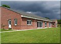
Dinton Village Hall
The hall is in Bratch Lane and was built in 2000.
Image: © Maigheach-gheal
Taken: 15 Jun 2008
0.06 miles
4
![Dinton buildings [5]](https://s3.geograph.org.uk/geophotos/07/34/67/7346739_05b53620_120x120.jpg)
Dinton buildings [5]
This former bakehouse, one of the outbuildings of Little Clarendon Image, was converted and furnished as a Roman Catholic chapel dedicated to Our Lady of Pity. The chapel and vestments are still kept in occasional use.
Little Clarendon, Hindon Road, was originally a hall house built in the late 15th century, probably altered including heightening in the late 17th century and greatly restored in the early 20th century. Constructed of rubble stone under a tile roof. Many early internal features remain. Now in the ownership of the National Trust. There is another view of the house at Image Listed, grade II*, with details at: https://historicengland.org.uk/listing/the-list/list-entry/1146116
Dinton is a village in the Nadder valley, in Wiltshire, about 8¼ miles west of Salisbury and some 10½ miles northeast of Shaftesbury. Evidence of ancient settlement in the area is plentiful, including Grim's Ditch, Hanging Langford Camp, an Iron Age settlement, and the hill fort of Wick Ball Camp. Dinton is now a commuter village with most working residents travelling to Salisbury.
Image: © Michael Dibb
Taken: 30 Aug 2022
0.08 miles
5
![Dinton buildings [4]](https://s3.geograph.org.uk/geophotos/07/34/67/7346735_83fd3267_120x120.jpg)
Dinton buildings [4]
These outbuildings belong to Little Clarendon, Hindon Road, Image Built at various dates and constructed of a mixture of rubble stone and brick under roofs of thatch or of tile.
Little Clarendon, Hindon Road, was originally a hall house built in the late 15th century, probably altered including heightening in the late 17th century and greatly restored in the early 20th century. Constructed of rubble stone under a tile roof. Many early internal features remain. Now in the ownership of the National Trust. There is another view of the house at Image Listed, grade II*, with details at: https://historicengland.org.uk/listing/the-list/list-entry/1146116
Dinton is a village in the Nadder valley, in Wiltshire, about 8¼ miles west of Salisbury and some 10½ miles northeast of Shaftesbury. Evidence of ancient settlement in the area is plentiful, including Grim's Ditch, Hanging Langford Camp, an Iron Age settlement, and the hill fort of Wick Ball Camp. Dinton is now a commuter village with most working residents travelling to Salisbury.
Image: © Michael Dibb
Taken: 30 Aug 2022
0.09 miles
6
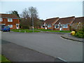
The Orange Way in Wiltshire (103)
The Orange Way crosses the road called Spracklands.
To proceed to the next section of the Orange Way go to www.geograph.org.uk/geotrips/567.
Image: © Shazz
Taken: 21 Apr 2013
0.10 miles
7
![Dinton houses [11]](https://s2.geograph.org.uk/geophotos/07/34/67/7346730_a97d387b_120x120.jpg)
Dinton houses [11]
Little Clarendon, Hindon Road, was originally a hall house built in the late 15th century, probably altered including heightening in the late 17th century and greatly restored in the early 20th century. Constructed of rubble stone under a tile roof. Many early internal features remain. Now in the ownership of the National Trust. There is another view of the house at Image Listed, grade II*, with details at: https://historicengland.org.uk/listing/the-list/list-entry/1146116
Dinton is a village in the Nadder valley, in Wiltshire, about 8¼ miles west of Salisbury and some 10½ miles northeast of Shaftesbury. Evidence of ancient settlement in the area is plentiful, including Grim's Ditch, Hanging Langford Camp, an Iron Age settlement, and the hill fort of Wick Ball Camp. Dinton is now a commuter village with most working residents travelling to Salisbury.
Image: © Michael Dibb
Taken: 30 Aug 2022
0.10 miles
8
![Dinton houses [12]](https://s3.geograph.org.uk/geophotos/07/34/67/7346731_ea2de7a6_120x120.jpg)
Dinton houses [12]
Little Clarendon, Hindon Road, was originally a hall house built in the late 15th century, probably altered including heightening in the late 17th century and greatly restored in the early 20th century. Constructed of rubble stone under a tile roof. Many early internal features remain. Now in the ownership of the National Trust. There is another view of the house at Image Listed, grade II*, with details at: https://historicengland.org.uk/listing/the-list/list-entry/1146116
Dinton is a village in the Nadder valley, in Wiltshire, about 8¼ miles west of Salisbury and some 10½ miles northeast of Shaftesbury. Evidence of ancient settlement in the area is plentiful, including Grim's Ditch, Hanging Langford Camp, an Iron Age settlement, and the hill fort of Wick Ball Camp. Dinton is now a commuter village with most working residents travelling to Salisbury.
Image: © Michael Dibb
Taken: 30 Aug 2022
0.10 miles
9
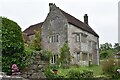
Little Clarendon, Dinton
Fifteenth Century house managed by the National Trust, but currently closed to visitors.
Image: © David Martin
Taken: 5 Jun 2022
0.10 miles
10
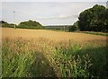
Field at Dinton
At last, after a nightmarish twenty minutes, I have found footpath DINT 13; it actually runs to the left of the camera up the side of the field. The path has been truncated by buildings; it starts from the B3069 and then gives up, re-emerging at this point from an alley beside Spracklands. Trouble is, the OS map shows it as continuous, and also shows the new buildings, so one would assume, as I did, that the two co-exist. No they don't. I went backwards and forwards about five times. What with problems with several footpaths at Fovant, and the tiring nature of such issues after many miles on the hoof, I've lost about an hour.
For the record, another path, DINT 5, runs blithely from west to east here, crossing this field.
Image: © Derek Harper
Taken: 27 Jun 2015
0.11 miles