IMAGES TAKEN NEAR TO
The Ridge, SALISBURY, SP3 5SD
Introduction
This page details the photographs taken nearby to The Ridge, SP3 5SD by members of the Geograph project.
The Geograph project started in 2005 with the aim of publishing, organising and preserving representative images for every square kilometre of Great Britain, Ireland and the Isle of Man.

There are currently over 7.5m images from over14,400 individuals and you can help contribute to the project by visiting https://www.geograph.org.uk
Image Map
Images are licensed for reuse under creativecommons.org/licenses/by-sa/2.0
Notes
- Clicking on the map will re-center to the selected point.
- The higher the marker number, the further away the image location is from the centre of the postcode.
Image Listing (19 Images Found)
Images are licensed for reuse under creativecommons.org/licenses/by-sa/2.0
Image
Details
Distance
1
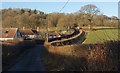
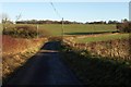
Paddock Lane
The lane to Ridge passes The Quadrangle in winter sunlight. Shortly beyond the large oak tree it reaches Image
Image: © Derek Harper
Taken: 9 Jan 2011
0.02 miles
2
The Quadrangle
The farm sits in a dry valley on the edge of the Fonthill estate. Beyond can be seen Mill Lane, leading up onto Lady Down. View from the drive shown in Image
Image: © Derek Harper
Taken: 9 Jan 2011
0.05 miles
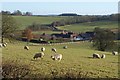
4
Fence at The Quadrangle
Seen from the stretch of drive shown in Image, with the farm The Quadrangle partly obscured by sheep catching the low winter sun.
Image: © Derek Harper
Taken: 9 Jan 2011
0.09 miles
5
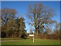
Green, Ridge
A triangular green by Paddock Lane; the sign says "Private road {to} Fonthill House", though it is also followed by a public footpath for nearly 400 metres. Contrast makes the sign illegible in the photo.
Image: © Derek Harper
Taken: 9 Jan 2011
0.09 miles
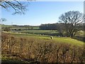
6
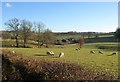
Sheep near Ridge
A similar view to Image taken a little further east along the drive from Fonthill. Trees follow a field boundary down a branch of the dry valley towards The Quadrangle.
Image: © Derek Harper
Taken: 9 Jan 2011
0.11 miles
7
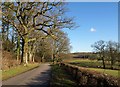
Drive from Fonthill House
Image: © Derek Harper
Taken: 9 Jan 2011
0.11 miles
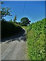
8
Drive to Fonthill House
A reverse view of the tree-lined Image from close to the junction with the lane at Ridge.
Image: © Derek Harper
Taken: 9 Jan 2011
0.12 miles
9
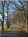
Paddock Lane
Paddock Lane approaches the junction with Mill Lane, which follows the dry valley up to its head to the right.
Image: © Derek Harper
Taken: 9 Jan 2011
0.15 miles
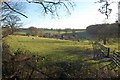
10
Sheep near Ridge
Taken from the same spot as Image The field drops into the dry valley the head of which is shown in Image Woollard Copse is in the background; the farm on the left is The Quadrangle.
Image: © Derek Harper
Taken: 9 Jan 2011
0.16 miles