IMAGES TAKEN NEAR TO
Ladydown, SALISBURY, SP3 5FA
Introduction
This page details the photographs taken nearby to Ladydown, SP3 5FA by members of the Geograph project.
The Geograph project started in 2005 with the aim of publishing, organising and preserving representative images for every square kilometre of Great Britain, Ireland and the Isle of Man.

There are currently over 7.5m images from over14,400 individuals and you can help contribute to the project by visiting https://www.geograph.org.uk
Image Map (Loading...)


Getting Data...Please wait
Leaflet Map data © OpenStreetMap
Images are licensed for reuse under creativecommons.org/licenses/by-sa/2.0
Notes
- Clicking on the map will re-center to the selected point.
- The higher the marker number, the further away the image location is from the centre of the postcode.
Image Listing (23 Images Found)
Images are licensed for reuse under creativecommons.org/licenses/by-sa/2.0
Image
Details
Distance
1
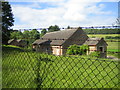
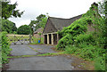
Former Site of RAF Chilmark 3
These are some of the now abandoned buildings of the former ammunition and bomb depot of RAF Chilmark taken from the unclassified road between Ham Cross and Chilmark. RAF Chilmark was first established in 1937 and closed in 1995. See Image for further details.
Image: © Andy Gryce
Taken: 6 Jul 2007
0.07 miles
2
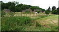
Former military buildings near Chilmark (1)
I was standing by the road scratching my head over the sight of these rather random-looking, apparently disused, buildings (scattered amongst which were several battered old cars with ACME and stick-men daubed on their sides) when a gent cycled by and shed light on the mystery.
The buildings originally belonged to the RAF Chilmark base, which was decommissioned in 1996, and are now used by ISSEE who organise anti-terrorism training for domestic and international governments and law enforcement agencies.
See Andy Gryce's photo for more information: Image]
Image: © Stephen Richards
Taken: Unknown
0.09 miles
3
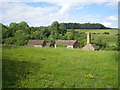
Former Site of RAF Chilmark 2
These are some of the buildings of the former ammunition and bomb depot of RAF Chilmark taken from the unclassified road between Ham Cross and Chilmark. The building with the chimney may be the heating plant for the nearby buildings. RAF Chilmark was first established in 1937 and closed in 1995. See Imagefor further details. On the hill in the distance is Lower Holt Copse, which is ancient replanted woodland.
Image: © Andy Gryce
Taken: 6 Jul 2007
0.09 miles
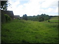
4
Former Site of RAF Chilmark 4
These are some of the abandoned buildings of the former ammunition and bomb depot of RAF Chilmark. The depot was first established in 1937 and closed in 1995. See Image for further details. This picture is taken from the bridleway that runs between the nearby Ham Cross to Chilmark unclassified road and the village of Teffont Evias.
Image: © Andy Gryce
Taken: 6 Jul 2007
0.10 miles
5

Former Site of RAF Chilmark
This is an entrance to the former ammunition and bomb depot of RAF Chilmark and shows a possible guardhouse with another building beyond. This picture is taken from the bridleway that runs between the nearby Ham Cross to Chilmark unclassified road and the village of Teffont Evias.
Chilmark Quarries and its underground limestone mines about 500m to the north, and the surrounding land, were acquired by the Air Ministry in 1936 and served as a bomb store, RAF Chilmark, throughout WWII. The depot had a narrow gauge railway, Image, and there was a transfer station at Ham Cross 1km to the south with a 4km spur from the main line at Dinton. The first consignment of war stores arrived in May 1937. There were also immense surface storage bomb and ammunition dumps in other locations in the area, particularly in Grovely Woods about 7km by road to the north-east, see one of the concrete roads from Chilmark to the bomb dumps, Image
Unlike most other RAF depots, Chilmark continued in use after the war. In 1994 supplies were transferred to the Nato depot at Glen Douglas in Scotland, prior to the complete closure of Chilmark in April 1995 with the loss of 200 jobs. Since then the site has been cleared of explosives, and much of the land towards Dinton has been sold off. In 1985 a bunker was built in the southern part of the site to serve as a Regional Government Headquarters, see http://www.subbrit.org.uk/rsg/features/sfs/file_11.htm , but this was decommissioned and sold in 1997.
Much of the site around Chilmark Quarries remains in Ministry of Defence ownership, and includes two Sites of Special Scientific Interest (SSSI), see Image
Image: © Andy Gryce
Taken: 6 Jul 2007
0.10 miles
6
Former military buildings near Chilmark (2)
Very little has changed in the three years since Andy Gryce's photo: Image
I was standing by the road scratching my head over the sight of these rather random-looking, apparently disused, buildings (scattered amongst which were several battered old cars with ACME and stick-men daubed on their sides) when a gent cycled by and shed light on the mystery.
The buildings originally belonged to the RAF Chilmark base, which was decommissioned in 1996, and are now used by ISSEE who organise anti-terrorism training for domestic and international governments and law enforcement agencies.
Image: © Stephen Richards
Taken: Unknown
0.10 miles
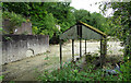
7
Narrow Gauge Railway, Former Site of RAF Chilmark 2
This is the overgrown trackbed of the dismantled narrow gauge railway of the former ammunition and bomb depot of RAF Chilmark, see Image The trackbed goes in the direction of Chilmark Quarries 500m away. To the left are some of the abandoned buildings of the depot. RAF Chilmark was first established in 1937 and closed in 1995. The picture is taken from the bridleway that runs between the nearby Ham Cross to Chilmark unclassified road and the village of Teffont Evias.
Image: © Andy Gryce
Taken: 6 Jul 2007
0.11 miles
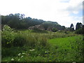
8
Former quarry near Chilmark (2)
Sadly, the quarry has closed, though Chilmark stone is still quarried nearby, at Chicksgrove. See this photo for more information about the stone: Image
Image: © Stephen Richards
Taken: Unknown
0.12 miles
9
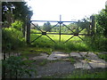
Narrow Gauge Railway, Former Site of RAF Chilmark
In front of this gate are the embedded double track rails of the disused narrow gauge railway of the former ammunition and bomb depot of RAF Chilmark which lies beyond the gate. The picture is taken from the bridleway that runs between the nearby Ham Cross to Chilmark unclassified road and the village of Teffont Evias.
The two-foot gauge railway was used to carry manufactured bombs for storage in the underground limestone mines of Chilmark Quarries, or for transport by road to nearby surface storage dumps, particularly during WWII. At Ham Cross about 1km to the south, there was a transfer station between the narrow gauge railway and a 4km standard gauge spur from the Salisbury to Yeovil main line near Dinton. RAF Chilmark was first established in 1937, and when the depot was closed in 1995, a number of electric battery and diesel locomotives were still in use. See Image for further details.
Image: © Andy Gryce
Taken: 6 Jul 2007
0.13 miles
10
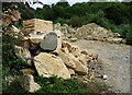
Former quarry near Chilmark (3)
Sadly, the quarry has closed, but this stone has been left behind. Chilmark stone is still quarried nearby, at Chicksgrove. See this photo for more information about the stone: Image
Image: © Stephen Richards
Taken: Unknown
0.14 miles