Former Site of RAF Chilmark
Introduction
The photograph on this page of Former Site of RAF Chilmark by Andy Gryce as part of the Geograph project.
The Geograph project started in 2005 with the aim of publishing, organising and preserving representative images for every square kilometre of Great Britain, Ireland and the Isle of Man.

There are currently over 7.5m images from over 14,400 individuals and you can help contribute to the project by visiting https://www.geograph.org.uk
Former Site of RAF Chilmark
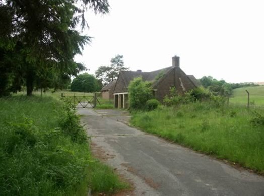
Image: © Andy Gryce Taken: 6 Jul 2007
This is an entrance to the former ammunition and bomb depot of RAF Chilmark and shows a possible guardhouse with another building beyond. This picture is taken from the bridleway that runs between the nearby Ham Cross to Chilmark unclassified road and the village of Teffont Evias. Chilmark Quarries and its underground limestone mines about 500m to the north, and the surrounding land, were acquired by the Air Ministry in 1936 and served as a bomb store, RAF Chilmark, throughout WWII. The depot had a narrow gauge railway, Image, and there was a transfer station at Ham Cross 1km to the south with a 4km spur from the main line at Dinton. The first consignment of war stores arrived in May 1937. There were also immense surface storage bomb and ammunition dumps in other locations in the area, particularly in Grovely Woods about 7km by road to the north-east, see one of the concrete roads from Chilmark to the bomb dumps, Image Unlike most other RAF depots, Chilmark continued in use after the war. In 1994 supplies were transferred to the Nato depot at Glen Douglas in Scotland, prior to the complete closure of Chilmark in April 1995 with the loss of 200 jobs. Since then the site has been cleared of explosives, and much of the land towards Dinton has been sold off. In 1985 a bunker was built in the southern part of the site to serve as a Regional Government Headquarters, see http://www.subbrit.org.uk/rsg/features/sfs/file_11.htm , but this was decommissioned and sold in 1997. Much of the site around Chilmark Quarries remains in Ministry of Defence ownership, and includes two Sites of Special Scientific Interest (SSSI), see Image
Images are licensed for reuse under creativecommons.org/licenses/by-sa/2.0
Image Location


Leaflet Map data © OpenStreetMap
Latitude
51.076699
Longitude
-2.033494