IMAGES TAKEN NEAR TO
Dairylea, SALISBURY, SP3 5AX
Introduction
This page details the photographs taken nearby to Dairylea, SP3 5AX by members of the Geograph project.
The Geograph project started in 2005 with the aim of publishing, organising and preserving representative images for every square kilometre of Great Britain, Ireland and the Isle of Man.

There are currently over 7.5m images from over14,400 individuals and you can help contribute to the project by visiting https://www.geograph.org.uk
Image Map (Loading...)


Getting Data...Please wait
Leaflet Map data © OpenStreetMap
Images are licensed for reuse under creativecommons.org/licenses/by-sa/2.0
Notes
- Clicking on the map will re-center to the selected point.
- The higher the marker number, the further away the image location is from the centre of the postcode.
Image Listing (16 Images Found)
Images are licensed for reuse under creativecommons.org/licenses/by-sa/2.0
Image
Details
Distance
1
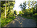
The Street, Chilmark 3
The Street is the main street of the village of Chilmark, see Image Here at the southern end of The Street there is a small bridge over the currently dried up stream that runs through the village. The road comes to a junction at the hamlet of Mooray about 80m ahead.
Image: © Andy Gryce
Taken: 29 Jun 2007
0.04 miles
2
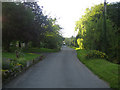
The Street, Chilmark 2
The Street is the main street of the village of Chilmark off which lies the church, school, and innumerable stone-built and often thatched cottages. This view looking north-west is of the tree-lined south end of The Street with houses set back from the road. On the right a dried up stream bed runs alongside the road. See also Image
Image: © Andy Gryce
Taken: 29 Jun 2007
0.06 miles
3
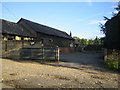
Cleeves Farm, Mooray, Chilmark
This is the entrance to Cleeves Farm in the hamlet of Mooray next to the village of Chilmark. On the OS map the farm is named Cleeve Farm but the sign at the entrance, and the address elsewhere, is given as Cleeves.
Image: © Andy Gryce
Taken: 29 Jun 2007
0.07 miles
4
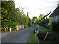
The Street, Chilmark
The Street is the main street of the village of Chilmark off which lies the church, school, and innumerable stone-built and often thatched cottages. Here, halfway along the street and looking south-east, there is a small bridge over the currently dried up stream that runs through the village. The northern end of the street near the village church, and behind the camera, is in the next grid square. The Street is quiet because the main road, the B3089 from Salisbury to Hindon, runs east-west through the north side of the village.
The name Chilmark comes from the Anglo-Saxon, 'cild' for child, or 'cigel', a pole or peg, and 'mearc' meaning boundary. For more information about the history of Chilmark, see http://www.nadderfocus.com/Villages/Chilmark/chil1.htm#history.
Stone from the nearby Chilmark quarries was used in the building of both the cathedral at Old Sarum and the celebrated Gothic one in Salisbury, see http://www.wessexdlstone.com/history1.htm.
Image: © Andy Gryce
Taken: 29 Jun 2007
0.08 miles
6
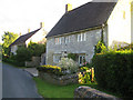
Houses, The Street, Chilmark
This cottage is halfway along The Street, the main street of the village of Chilmark, see Image, and is substantial compared with village houses generally. The cottage is built of local limestone probably from Chilmark Quarries south of the village, it has mullioned windows, and may be early 18th-century. There is a nameplate 'Taylors Cottage' though whether this has any historical significance is not known. The cottage is a listed building, and in the entry is called Olivers Cottage, http://www.imagesofengland.org.uk/Details/Default.aspx?id=320338&mode=quick,
Image: © Andy Gryce
Taken: 29 Jun 2007
0.11 miles
7
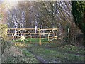
Gate, Chilmark
These gates appear to have real wheels attached to them as decoration.
Image: © Maigheach-gheal
Taken: 24 Jan 2010
0.18 miles
8
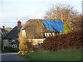
A patch on the thatch, Chilmark
The patch has been on the roof for some time as it is already growing moss.
Image: © Maigheach-gheal
Taken: 24 Jan 2010
0.20 miles
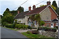
9
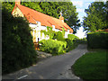
Cottages, Lower Mooray near Chilmark
This row of cottages lies at the southern end of the hamlet of Mooray next to the village of Chilmark. The road in front of the cottages, which comes from a right angled turn of an unclassified road just behind the camera, ends at the fence. Here the road becomes a bridleway that goes east beside Cleeve Copse and along the greensand ridge to Teffont Evias about 2km away.
Image: © Andy Gryce
Taken: 29 Jun 2007
0.20 miles
10
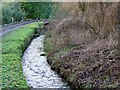
Stream, Chilmark
Just one of the small streams that flow in the area.
Image: © Maigheach-gheal
Taken: 24 Jan 2010
0.21 miles