
IMAGES TAKEN NEAR TO
Berwick St. James, SALISBURY, SP3 4TL
Introduction
This page details the photographs taken nearby to SP3 4TL by members of the Geograph project.
The Geograph project started in 2005 with the aim of publishing, organising and preserving representative images for every square kilometre of Great Britain, Ireland and the Isle of Man.

There are currently over 7.5m images from over14,400 individuals and you can help contribute to the project by visiting https://www.geograph.org.uk
Image Map
Images are licensed for reuse under creativecommons.org/licenses/by-sa/2.0
Notes
- Clicking on the map will re-center to the selected point.
- The higher the marker number, the further away the image location is from the centre of the postcode.
Image Listing (23 Images Found)
Images are licensed for reuse under creativecommons.org/licenses/by-sa/2.0
Image
Details
Distance
1
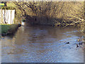
The River Till near Asserton
Unlike many of the chalk downland valleys across the Salisbury Plain, the valley of the River Till is the only one with a permanent flow of water. Numerous springs high up in the heart of the Plain continuously feed the little river, which rises near Tilshead and flows south through Shrewton, Winterbourne Stoke and Berwick St James before merging with the much larger River Wylye at Stapleford. Under normal conditions, even in the wettest of winters, the porous nature of chalk will absorb the rainfall, but occasionally under quite exceptional conditions flash floods can occur across chalk downland.
Image: © Maigheach-gheal
Taken: 13 Mar 2007
0.05 miles
2
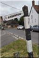
Old Direction Sign - Signpost by the B3083, Berwick St James
Pyramid top finial - 1 arm; Wilts wooden by the B3083, in parish of Berwick St James (Salisbury District), junction of Berwick Road with Duck Street, on grass triangle.
To be surveyed
Milestone Society National ID: WI_SU0739
Image: © Milestone Society
Taken: Unknown
0.05 miles
3
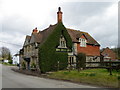
The Boot Inn, Berwick St James
An attractive stone and flint village local built in the 17th century and altered in the 1890's. It is Grade II listed and has a traditional unspoilt interior. There is an Ordnance Survey bench mark on the north west angle of the building.
Image: © Maigheach-gheal
Taken: 9 Mar 2011
0.07 miles
4
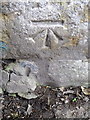
Bench Mark, The Boot Inn
The bench mark is to be found on the north west angle of the building. For a view of the building Image and for further information on the bench mark and others in the area http://www.bench-marks.org.uk/bm37646
Image: © Maigheach-gheal
Taken: 9 Mar 2011
0.07 miles
5
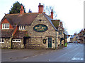
The Boot Inn, Berwick St James
An attractive stone and flint village local built in the 17th century and altered in the 1890's. It is Grade II listed and has a traditional unspoilt interior.
Image: © Maigheach-gheal
Taken: 8 Feb 2007
0.08 miles
6
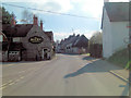
B3083 passes The Boot Inn
Here's another view of this Grade II listed pub. Although it dates from the 17th C. it was altered during 1890's but still warrants English Heritage Building ID: 320447.
Image: © Stuart Logan
Taken: 25 Apr 2013
0.09 miles
9

Postbox, Berwick st James
A George V reign postbox set into the wall of Post Office Cottage. The blue top bin is for recycling.
Image: © Maigheach-gheal
Taken: 14 Jan 2010
0.10 miles
10
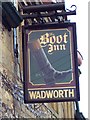
Sign for the Boot Inn, Berwick St James
Sign for Image
Image: © Maigheach-gheal
Taken: 8 Feb 2007
0.11 miles