IMAGES TAKEN NEAR TO
Little Langford, SALISBURY, SP3 4NX
Introduction
This page details the photographs taken nearby to SP3 4NX by members of the Geograph project.
The Geograph project started in 2005 with the aim of publishing, organising and preserving representative images for every square kilometre of Great Britain, Ireland and the Isle of Man.

There are currently over 7.5m images from over14,400 individuals and you can help contribute to the project by visiting https://www.geograph.org.uk
Image Map
Images are licensed for reuse under creativecommons.org/licenses/by-sa/2.0
Notes
- Clicking on the map will re-center to the selected point.
- The higher the marker number, the further away the image location is from the centre of the postcode.
Image Listing (64 Images Found)
Images are licensed for reuse under creativecommons.org/licenses/by-sa/2.0
Image
Details
Distance
1
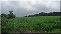
Farmland near Little Langford
This is maize, being grown for winter fodder (thanks to fellow Geographer, Fasgadh).
The field lies between the River Wylye on the left and the railway, behind the trees on the right.
Image: © Stephen Richards
Taken: Unknown
0.14 miles
2
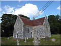
St. Nicholas, Little Langford: churchyard (A)
Image: © Basher Eyre
Taken: 19 Aug 2016
0.16 miles
3
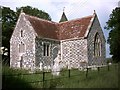
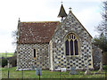
St. Nicholas' church Little Langford
A little Victorian church with a remarkable Norman doorway
Image: © Kevin Farmer
Taken: Unknown
0.16 miles
4
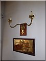
Inside St. Nicholas, Little Langford (D)
Image: © Basher Eyre
Taken: 19 Aug 2016
0.17 miles
5
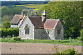
The Church of St. Nicholas of Mira, Little Langford
St Nicholas of Mira, has gone down in history as Santa Claus. The church was largely rebuilt in 1863-4 by T.H. Wyatt.
Image: © Maigheach-gheal
Taken: 2 Feb 2007
0.17 miles
6
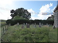
St. Nicholas, Little Langford: churchyard (B)
Image: © Basher Eyre
Taken: 19 Aug 2016
0.17 miles
8
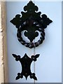
Detail, The Church of St Nicholas of Mira
The handle to the main door to the church. For a wider view of the church Image
Image: © Maigheach-gheal
Taken: 26 Jul 2010
0.17 miles
9
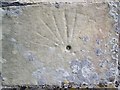
Scratch dial, The Church of St. Nicholas of Mira
Normally located near the south porch of old churches. Usually about six to ten inches across with radiating lines coming from a central hole. These were used by priests as clocks to determine the time for mass. A wooden peg known as a gnomon (Greek indicator) was placed in the hole and the shadow cast by the sun moved round the dial. When the shadow touched one of the radiating lines it was time for a mass.
For a view of the church Image
Image: © Maigheach-gheal
Taken: 26 Jul 2010
0.17 miles
10
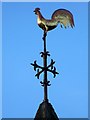
Weather cock, The Church of St. Nicholas of Mira
It was a papal edict in the 9th century that was responsible for the proliferation of weathercocks on churches. This edict required every Church in Christendom to be mounted by a cockerel. This symbol was to recall Peter's betrayal of Christ (LUKE 22:34) "I tell thee, Peter, the cock shall not crow this day, before that thou shalt thrice deny that thou knowest me". Although only the symbol of the cockerel was required by the edict, the motif, it seems, was quickly wedded with the weathervane. By the 13th century the word for weathercock (gallum) and weathervane (ventrologium) had become interchangeable. Interestingly, early weathercocks did not include cardinal letters, as Christian churches always lay east to west.
For a view of the church Image
Image: © Maigheach-gheal
Taken: 26 Jul 2010
0.17 miles