IMAGES TAKEN NEAR TO
Wyndham Mount, SALISBURY, SP3 4NL
Introduction
This page details the photographs taken nearby to Wyndham Mount, SP3 4NL by members of the Geograph project.
The Geograph project started in 2005 with the aim of publishing, organising and preserving representative images for every square kilometre of Great Britain, Ireland and the Isle of Man.

There are currently over 7.5m images from over14,400 individuals and you can help contribute to the project by visiting https://www.geograph.org.uk
Image Map (Loading...)


Getting Data...Please wait
Leaflet Map data © OpenStreetMap
Images are licensed for reuse under creativecommons.org/licenses/by-sa/2.0
Notes
- Clicking on the map will re-center to the selected point.
- The higher the marker number, the further away the image location is from the centre of the postcode.
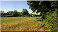
Image Listing (35 Images Found)
Images are licensed for reuse under creativecommons.org/licenses/by-sa/2.0
Image
Details
Distance
1
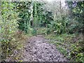
Bridleway, Hanging Langford
Looking back down the muddy bridleway towards the railway bridge.
Image: © Maigheach-gheal
Taken: 24 Nov 2008
0.07 miles
2
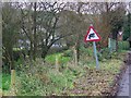
Beware Frogs
Just as the minor road arrives in Hanging Langford, drivers are warned that frogs may be crossing.
Image: © Maigheach-gheal
Taken: 24 Nov 2008
0.10 miles
3
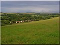
The Wylye valley, Hanging Langford
A train making its way to Salisbury (i.e. away from us) above houses at the east end of Hanging Langford.
Image: © Andrew Smith
Taken: 23 Jun 2007
0.12 miles
4
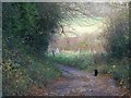
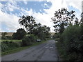
Byway to Hanging Langford
The byway heads down hill towards the railway and then on to the village of Hanging Langford.
Image: © Maigheach-gheal
Taken: 24 Nov 2008
0.14 miles
6
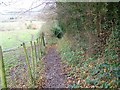
Bridleway to Hanging Langford
The bridleway passes between paddocks and a high hedge on its way from Grovely Woods to Hanging Langford.
Image: © Maigheach-gheal
Taken: 24 Nov 2008
0.16 miles
7
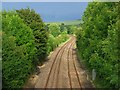
Railway, Hanging Langford
Viewed from a byway (The Hollow), looking towards Salisbury.
Image: © Andrew Smith
Taken: 23 Jun 2007
0.16 miles
8

Meadow, Langford Lakes Nature Reserve
The gate leads one across this meadow towards the Glebe Walk, among trees along a channel on the southern side of the Wylye flood plain.
Image: © Derek Harper
Taken: 30 Jun 2018
0.16 miles
9
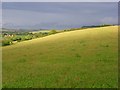
Downland, Hanging Langford
The southern flank of the Wylye valley. The railway can just be seen below.
Image: © Andrew Smith
Taken: 23 Jun 2007
0.17 miles
10
Meadow, Langford Lakes Nature Reserve
Looking right from the gate where Image] was taken, with vehicles parked along Duck Street, their occupants doubtless in the River Wylye on a glorious day. The building with the hipped roof is a pump house.
Image: © Derek Harper
Taken: 30 Jun 2018
0.17 miles