IMAGES TAKEN NEAR TO
Salisbury Road, SALISBURY, SP3 4NA
Introduction
This page details the photographs taken nearby to Salisbury Road, SP3 4NA by members of the Geograph project.
The Geograph project started in 2005 with the aim of publishing, organising and preserving representative images for every square kilometre of Great Britain, Ireland and the Isle of Man.

There are currently over 7.5m images from over14,400 individuals and you can help contribute to the project by visiting https://www.geograph.org.uk
Image Map (Loading...)


Getting Data...Please wait
Leaflet Map data © OpenStreetMap
Images are licensed for reuse under creativecommons.org/licenses/by-sa/2.0
Notes
- Clicking on the map will re-center to the selected point.
- The higher the marker number, the further away the image location is from the centre of the postcode.
Image Listing (115 Images Found)
Images are licensed for reuse under creativecommons.org/licenses/by-sa/2.0
Image
Details
Distance
1
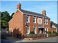
Bell House
With a prominent datestone of 1880 the building is a former public house.
Image: © Michael Dibb
Taken: 25 Jul 2018
0.01 miles

3

Fern Cottage
Built in the late 17th century of flint and limestone chequerwork, this delightful thatched cottage is listed, grade II, with details at: https://www.historicengland.org.uk/listing/the-list/list-entry/1146197
Image: © Michael Dibb
Taken: 25 Jul 2018
0.03 miles
4
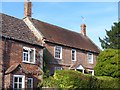
Large Cottage
At the end of the row, Large Cottage was built in the late 17th century and altered circa 1800. Listed, grade II, with details at: https://www.historicengland.org.uk/listing/the-list/list-entry/1284205
Image: © Michael Dibb
Taken: 25 Jul 2018
0.03 miles
5
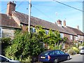
Two cottages
This row of three cottages is now two - number 17, The Old Cottage, and number 15. With a datestone of 1788, the cottages are listed, grade II, with details at: https://www.historicengland.org.uk/listing/the-list/list-entry/1318703
Image: © Michael Dibb
Taken: 25 Jul 2018
0.04 miles
6
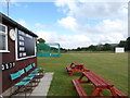
Steeple Langford Cricket Club: mid August 2016
Image: © Basher Eyre
Taken: 19 Aug 2016
0.05 miles
7
Swaynes
This classical early 19th century house with an attached stable block is listed, grade II, with details at: https://www.historicengland.org.uk/listing/the-list/list-entry/1146237
Image: © Michael Dibb
Taken: 25 Jul 2018
0.06 miles
8
![Montrose House [3]](https://s2.geograph.org.uk/geophotos/05/88/94/5889486_f27a8acd_120x120.jpg)
Montrose House [3]
A view of Montrose House which was until 1961 The Rectory. Built of chequered flint and limestone circa 1700 with late 19th century additions. Listed, grade II, with details at: https://www.historicengland.org.uk/listing/the-list/list-entry/1183051
Image: © Michael Dibb
Taken: 25 Jul 2018
0.07 miles
9
![Montrose House [2]](https://s1.geograph.org.uk/geophotos/05/88/94/5889485_7ff8768f_120x120.jpg)
Montrose House [2]
The north facade of Montrose House which was until 1961 The Rectory. Built of chequered flint and limestone circa 1700 with late 19th century additions. Listed, grade II, with details at: https://www.historicengland.org.uk/listing/the-list/list-entry/1183051
Image: © Michael Dibb
Taken: 25 Jul 2018
0.08 miles
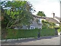
10
![Montrose House [1]](https://s3.geograph.org.uk/geophotos/05/88/94/5889483_13bd6c80_120x120.jpg)
Montrose House [1]
A glimpse of the roof of Montrose House which was until 1961 The Rectory. Built of chequered flint and limestone circa 1700 with late 19th century additions. Listed, grade II, with details at: https://www.historicengland.org.uk/listing/the-list/list-entry/1183051
Image: © Michael Dibb
Taken: 25 Jul 2018
0.08 miles