IMAGES TAKEN NEAR TO
Wilman Way, SALISBURY, SP2 8QS
Introduction
This page details the photographs taken nearby to Wilman Way, SP2 8QS by members of the Geograph project.
The Geograph project started in 2005 with the aim of publishing, organising and preserving representative images for every square kilometre of Great Britain, Ireland and the Isle of Man.

There are currently over 7.5m images from over14,400 individuals and you can help contribute to the project by visiting https://www.geograph.org.uk
Image Map
Images are licensed for reuse under creativecommons.org/licenses/by-sa/2.0
Notes
- Clicking on the map will re-center to the selected point.
- The higher the marker number, the further away the image location is from the centre of the postcode.
Image Listing (17 Images Found)
Images are licensed for reuse under creativecommons.org/licenses/by-sa/2.0
Image
Details
Distance
1
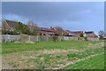
Houses on the edge of Salisbury
Modern development on the site of the former Harvard Hospital and Common Cold Research Centre.
Image: © David Martin
Taken: 22 Mar 2014
0.11 miles
2
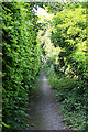
Footpath from Bouverie Avenue to Old Blandford Road, Salisbury
This narrow path wends its way between the gardens of the adjoining houses.
Image: © Peter Facey
Taken: 30 Jun 2006
0.12 miles
4
Footpath to Harnham
An obvious route into Harnham if approaching from the south, although a route to the west keeps you in countryside a bit longer.
Image: © Graham Horn
Taken: 4 Dec 2008
0.19 miles
5
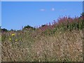
Rosebay Willowherb
It is sometimes called fire weed as it is one of the first plants to establish after ground has been burnt.
Image: © Maigheach-gheal
Taken: 31 Jul 2007
0.19 miles
6
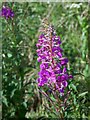
Rosebay Willowherb
Rosebay Willowherb, introduced from China by the Victorians which very quickly established and naturalised.
Image: © Maigheach-gheal
Taken: 31 Jul 2007
0.19 miles

8
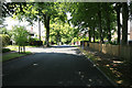
Bouverie Avenue South, Salisbury
One of the older residential parts on Harnham Hill. The turning at left is Bouverie Close.
Image: © Peter Facey
Taken: 30 Jun 2006
0.19 miles
9
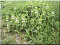
Dead Nettle (Lamium album)
Common names are archangel, white archangel, blind nettle, dumb nettle, deaf nettle and blind nettle. The plant flowers in the early spring and summer. It grows in woods, ditches and disturbed ground. It is unrelated to the stinging nettle.
Image: © Maigheach-gheal
Taken: 17 Apr 2007
0.21 miles
10
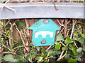
Sign for the Avon Valley Path
The Avon Valley Path is a 34-mile, long-distance walking route that takes you from Salisbury to Christchurch Priory and the sea. It was opened in 1992 and runs from Wiltshire due south through Hampshire to finish in Dorset. The Path is named after the river whose course it follows. It is good to remember that this route can become seriously waterlogged from December to May.
Image: © Maigheach-gheal
Taken: 17 Apr 2007
0.21 miles