IMAGES TAKEN NEAR TO
Swallowmead, SALISBURY, SP2 8JD
Introduction
This page details the photographs taken nearby to Swallowmead, SP2 8JD by members of the Geograph project.
The Geograph project started in 2005 with the aim of publishing, organising and preserving representative images for every square kilometre of Great Britain, Ireland and the Isle of Man.

There are currently over 7.5m images from over14,400 individuals and you can help contribute to the project by visiting https://www.geograph.org.uk
Image Map
Images are licensed for reuse under creativecommons.org/licenses/by-sa/2.0
Notes
- Clicking on the map will re-center to the selected point.
- The higher the marker number, the further away the image location is from the centre of the postcode.
Image Listing (10 Images Found)
Images are licensed for reuse under creativecommons.org/licenses/by-sa/2.0
Image
Details
Distance
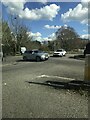
1
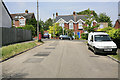
Meyrick Avenue looking onto Bouverie Avenue, Salisbury
A residential area on the 100m high hill at Harnham.
Image: © Peter Facey
Taken: 30 Jun 2006
0.13 miles
2
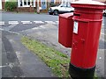
Postbox, Harnham
A Victorian reign postbox on the corner of Meyrick Avenue.
Image: © Maigheach-gheal
Taken: 4 Feb 2010
0.14 miles
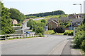
4
Bouverie Avenue South, Salisbury
One of the older residential parts on Harnham Hill. The turning at left is Bouverie Close.
Image: © Peter Facey
Taken: 30 Jun 2006
0.17 miles
5
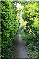
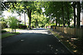
Footpath from Bouverie Avenue to Old Blandford Road, Salisbury
This narrow path wends its way between the gardens of the adjoining houses.
Image: © Peter Facey
Taken: 30 Jun 2006
0.19 miles
7
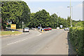
Roundabout on A354, Harnham, Salisbury
A354 goes straight ahead; right is to Odstock; left is Bouverie Avenue.
Image: © Peter Facey
Taken: 30 Jun 2006
0.19 miles
8
Odstock Road, Salisbury
Looking down Odstock Road from Coombe Road. Salisbury District Hospital is over the horizon right.
Image: © Peter Facey
Taken: 30 Jun 2006
0.22 miles
9
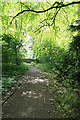
Woodland north of Bouverie Avenue, Harnham, Salisbury
This is the area to which the steps in Image lead. In distance is the path running from right to left across the picture and leading to the Avenue.
Image: © Peter Facey
Taken: 30 Jun 2006
0.24 miles
10
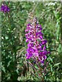
Rosebay Willowherb
Rosebay Willowherb, introduced from China by the Victorians which very quickly established and naturalised.
Image: © Maigheach-gheal
Taken: 31 Jul 2007
0.25 miles