IMAGES TAKEN NEAR TO
Lower Street, SALISBURY, SP2 8HB
Introduction
This page details the photographs taken nearby to Lower Street, SP2 8HB by members of the Geograph project.
The Geograph project started in 2005 with the aim of publishing, organising and preserving representative images for every square kilometre of Great Britain, Ireland and the Isle of Man.

There are currently over 7.5m images from over14,400 individuals and you can help contribute to the project by visiting https://www.geograph.org.uk
Image Map
Images are licensed for reuse under creativecommons.org/licenses/by-sa/2.0
Notes
- Clicking on the map will re-center to the selected point.
- The higher the marker number, the further away the image location is from the centre of the postcode.
Image Listing (150 Images Found)
Images are licensed for reuse under creativecommons.org/licenses/by-sa/2.0
Image
Details
Distance
1
![Salisbury houses [10]](https://s3.geograph.org.uk/geophotos/06/39/15/6391595_e528412d_120x120.jpg)
Salisbury houses [10]
This row of five cottages, numbers 5 to 9 Middle Street were built circa 1800. Listed, grade II, with details at: https://historicengland.org.uk/listing/the-list/list-entry/1242792
A cathedral was established at the Iron Age hillfort of Old Sarum by the Normans. In 1220 the cathedral was removed to the nearby plain and New Sarum (Salisbury) grew up around it, receiving a city charter in 1227. Located at the confluence of five rivers (Avon, Nadder, Ebble, Wylye and Bourne) the city is prone to flooding. Traffic between the ports of Southampton and Bristol, passes around the city's ring-road via the A36 causing much congestion.
Image: © Michael Dibb
Taken: 31 Dec 2019
0.01 miles
2
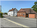
The Cottages and The Old Dairy
Houses on Middle Street. The Cottages, on the left, date from c.1800 and The Old Dairy from the 18th/19th Century. Both are grade II listed - see https://historicengland.org.uk/listing/the-list/list-entry/1242792?section=official-list-entry and https://historicengland.org.uk/listing/the-list/list-entry/1023679?section=official-list-entry respectively.
Image: © Ian Capper
Taken: 17 Jun 2022
0.01 miles
3
![Salisbury buildings [14]](https://s2.geograph.org.uk/geophotos/06/39/19/6391994_961cc7df_120x120.jpg)
Salisbury buildings [14]
Described by Historic England as an 'outbuilding to west of Old Parsonage' it would appear to have been converted into a dwelling. Listed, grade II, with details at: https://historicengland.org.uk/listing/the-list/list-entry/1023679
A cathedral was established at the Iron Age hillfort of Old Sarum by the Normans. In 1220 the cathedral was removed to the nearby plain and New Sarum (Salisbury) grew up around it, receiving a city charter in 1227. Located at the confluence of five rivers (Avon, Nadder, Ebble, Wylye and Bourne) the city is prone to flooding. Traffic between the ports of Southampton and Bristol, passes around the city's ring-road via the A36 causing much congestion.
Image: © Michael Dibb
Taken: 31 Dec 2019
0.02 miles
4
![Salisbury buildings [13]](https://s1.geograph.org.uk/geophotos/06/39/19/6391993_78eab9eb_120x120.jpg)
Salisbury buildings [13]
The Old School at the junction of Lower Road and Netherhampton Road was built in 1863. It became a school for infants only in 1928 and closed in 1931. The school and schoolhouse were sold in 1951 and currently houses a taxi company. Listed, grade II, with details at: https://historicengland.org.uk/listing/the-list/list-entry/1258223
A cathedral was established at the Iron Age hillfort of Old Sarum by the Normans. In 1220 the cathedral was removed to the nearby plain and New Sarum (Salisbury) grew up around it, receiving a city charter in 1227. Located at the confluence of five rivers (Avon, Nadder, Ebble, Wylye and Bourne) the city is prone to flooding. Traffic between the ports of Southampton and Bristol, passes around the city's ring-road via the A36 causing much congestion.
Image: © Michael Dibb
Taken: 31 Dec 2019
0.02 miles
5
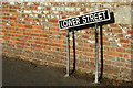
Lower Street, Salisbury
This road runs down towards the river, but the gradient is nowhere near as steep as the road sign might suggest.
Image: © Peter Trimming
Taken: 17 Nov 2009
0.02 miles
6
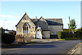
Former school, Harnham
From about 1850, grade II listed. Believed to be offices now.
Image: © Robin Webster
Taken: 16 Dec 2017
0.02 miles
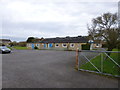
7
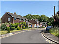
Mallard Close
Cul-de-sac off Lower Street.
Image: © Ian Capper
Taken: 17 Jun 2022
0.03 miles
8
![Salisbury houses [11]](https://s0.geograph.org.uk/geophotos/06/39/19/6391996_a3b0ff17_120x120.jpg)
Salisbury houses [11]
The Old Parsonage was originally a farmhouse. The six eastern bays (nearest the camera) are circa 1600, the two western bays are 16th century. A small addition to the north is 18th century. The southern front to the road is masked by tile-hanging and all openings are modern. One of the rooms has an ornate plaster ceiling of circa 1600. There is more details and a plan of the house (monument number 581) at https://www.british-history.ac.uk/rchme/salisbury/pp167-174 Listed, grade II, with details at: https://historicengland.org.uk/listing/the-list/list-entry/1260123
A cathedral was established at the Iron Age hillfort of Old Sarum by the Normans. In 1220 the cathedral was removed to the nearby plain and New Sarum (Salisbury) grew up around it, receiving a city charter in 1227. Located at the confluence of five rivers (Avon, Nadder, Ebble, Wylye and Bourne) the city is prone to flooding. Traffic between the ports of Southampton and Bristol, passes around the city's ring-road via the A36 causing much congestion.
Image: © Michael Dibb
Taken: 31 Dec 2019
0.04 miles
9
Harnham, church hall
On Middle Street, overlooking the recreation ground.
Image: © Mike Faherty
Taken: 14 Apr 2013
0.04 miles
10
![Salisbury houses [8]](https://s3.geograph.org.uk/geophotos/06/39/15/6391531_18edf941_120x120.jpg)
Salisbury houses [8]
A view from the churchyard of the rear of Manor Farmhouse. Built in the late 18th century and added to in the early 19th century. Listed, grade II, with details at: https://historicengland.org.uk/listing/the-list/list-entry/1242796
A cathedral was established at the Iron Age hillfort of Old Sarum by the Normans. In 1220 the cathedral was removed to the nearby plain and New Sarum (Salisbury) grew up around it, receiving a city charter in 1227. Located at the confluence of five rivers (Avon, Nadder, Ebble, Wylye and Bourne) the city is prone to flooding. Traffic between the ports of Southampton and Bristol, passes around the city's ring-road via the A36 causing much congestion.
Image: © Michael Dibb
Taken: 31 Dec 2019
0.06 miles