IMAGES TAKEN NEAR TO
Chiselbury Grove, SALISBURY, SP2 8EP
Introduction
This page details the photographs taken nearby to Chiselbury Grove, SP2 8EP by members of the Geograph project.
The Geograph project started in 2005 with the aim of publishing, organising and preserving representative images for every square kilometre of Great Britain, Ireland and the Isle of Man.

There are currently over 7.5m images from over14,400 individuals and you can help contribute to the project by visiting https://www.geograph.org.uk
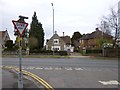
Image Map
Images are licensed for reuse under creativecommons.org/licenses/by-sa/2.0
Notes
- Clicking on the map will re-center to the selected point.
- The higher the marker number, the further away the image location is from the centre of the postcode.
Image Listing (150 Images Found)
Images are licensed for reuse under creativecommons.org/licenses/by-sa/2.0
Image
Details
Distance
1
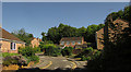
Chiselbury Grove, Salisbury
From the entrance to the cul-de-sac shown in Image], passed by the Avon Valley Path.
Image: © Derek Harper
Taken: 30 Jun 2018
0.03 miles
2
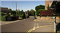
Old Blandford Road, Salisbury
Dropping past Chiselbury Grove, to meet the A3094 Harnham Road. This stretch of the Old Blandford Road is followed by the Avon Valley Path.
Image: © Derek Harper
Taken: 30 Jun 2018
0.04 miles
3
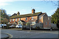
Houses on Old Blandford Road
A study in brickwork - the original row uses Sussex Bond, three stretchers to one header in each course, the extension to the right uses ordinary Stretcher Bond, no doubt to cheaply produce a cavity wall.
Image: © Robin Webster
Taken: 16 Dec 2017
0.04 miles
4
Harnham, Old Church School
On Harnham Road, next to All Saints'; now residential.
Image: © Mike Faherty
Taken: 14 Apr 2013
0.05 miles
5
![Salisbury buildings [18]](https://s1.geograph.org.uk/geophotos/06/39/20/6392065_a5332409_120x120.jpg)
Salisbury buildings [18]
Built with bands of stock brick and flint, this delightful small school, now a private dwelling, was erected circa 1860. Listed, grade II, with details at: https://historicengland.org.uk/listing/the-list/list-entry/1355802
A cathedral was established at the Iron Age hillfort of Old Sarum by the Normans. In 1220 the cathedral was removed to the nearby plain and New Sarum (Salisbury) grew up around it, receiving a city charter in 1227. Located at the confluence of five rivers (Avon, Nadder, Ebble, Wylye and Bourne) the city is prone to flooding. Traffic between the ports of Southampton and Bristol, passes around the city's ring-road via the A36 causing much congestion.
Image: © Michael Dibb
Taken: 31 Dec 2019
0.05 miles
6
![Salisbury houses [15]](https://s2.geograph.org.uk/geophotos/06/39/20/6392074_bd41e409_120x120.jpg)
Salisbury houses [15]
Rose and Crown Terrace, the odd numbers from 53 to 61 Harnham Road, is early 19th century. Number 61 is very different in style from the rest of the terrace. Listed, grade II, with details at: https://historicengland.org.uk/listing/the-list/list-entry/1023678
A cathedral was established at the Iron Age hillfort of Old Sarum by the Normans. In 1220 the cathedral was removed to the nearby plain and New Sarum (Salisbury) grew up around it, receiving a city charter in 1227. Located at the confluence of five rivers (Avon, Nadder, Ebble, Wylye and Bourne) the city is prone to flooding. Traffic between the ports of Southampton and Bristol, passes around the city's ring-road via the A36 causing much congestion.
Image: © Michael Dibb
Taken: 31 Dec 2019
0.05 miles
7
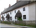
Thatched cottages, Harnham
Three 19th century thatched cottages of cob construction.
Image: © Maigheach-gheal
Taken: 16 Jul 2008
0.05 miles
8
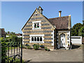
Former All Saints School
Former school on Harnham Road. Dating from 1853, it is grade II listed - see https://historicengland.org.uk/listing/the-list/list-entry/1355802?section=official-list-entry.
Image: © Ian Capper
Taken: 17 Jun 2022
0.05 miles
9
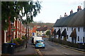
Harnham Road, Salisbury
Looking in the direction of the river, and Salisbury city centre. The red brick houses, on the left, and thatched cottages, on the right, made an interesting contrast.
Image: © Peter Trimming
Taken: 17 Nov 2009
0.06 miles
10
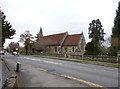
Harnham, All Saints'
Victorian parish church on Harnham Road: http://www.imagesofengland.org.uk/Details/Default.aspx?id=319164&mode=adv
Image: © Mike Faherty
Taken: 14 Apr 2013
0.06 miles