IMAGES TAKEN NEAR TO
Bouverie Avenue South, SALISBURY, SP2 8EB
Introduction
This page details the photographs taken nearby to Bouverie Avenue South, SP2 8EB by members of the Geograph project.
The Geograph project started in 2005 with the aim of publishing, organising and preserving representative images for every square kilometre of Great Britain, Ireland and the Isle of Man.

There are currently over 7.5m images from over14,400 individuals and you can help contribute to the project by visiting https://www.geograph.org.uk
Image Map (Loading...)


Getting Data...Please wait
Leaflet Map data © OpenStreetMap
Images are licensed for reuse under creativecommons.org/licenses/by-sa/2.0
Notes
- Clicking on the map will re-center to the selected point.
- The higher the marker number, the further away the image location is from the centre of the postcode.
Image Listing (20 Images Found)
Images are licensed for reuse under creativecommons.org/licenses/by-sa/2.0
Image
Details
Distance
1
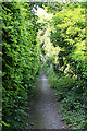
Footpath from Bouverie Avenue to Old Blandford Road, Salisbury
This narrow path wends its way between the gardens of the adjoining houses.
Image: © Peter Facey
Taken: 30 Jun 2006
0.07 miles
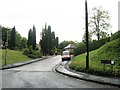
2
Old Blandford Road, Salisbury
Looking towards the crest of Harnham Hill. BBC Harnham television transmitter mast is nearby.
Image: © Peter Facey
Taken: 30 Jun 2006
0.11 miles

5
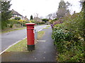
Harnham, postbox
EVIIR postbox, ID SP2 352, on Harnwood Road, at the junction with Old Blandford Road.
Image: © Mike Faherty
Taken: 14 Apr 2013
0.13 miles
6

Old Milestone by the A354, Coombe Road, Britford parish
Carved stone post by the A354, in parish of BRITFORD (SALISBURY District), Coombe Road; opposite No. 250, by the road, on South side of road. Sarum stone, erected by the Harnham, Blandford & Dorchester turnpike trust in the 19th century.
Inscription reads:-
To
SARUM
1
Blandford
21
Grade II listed.
List Entry Number: 1023796 https://historicengland.org.uk/listing/the-list/list-entry/1023796
Milestone Society National ID: WI_SABF01.
Image: © M Faherty
Taken: 20 Jan 2007
0.15 miles
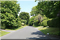
7
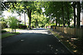
Bouverie Avenue South, Salisbury
One of the older residential parts on Harnham Hill. The turning at left is Bouverie Close.
Image: © Peter Facey
Taken: 30 Jun 2006
0.16 miles
8
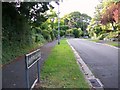
Harnwood Road, Salisbury
The leafy suburbs of Salisbury.
Image: © Maigheach-gheal
Taken: 14 Aug 2008
0.18 miles
9
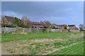
Houses on the edge of Salisbury
Modern development on the site of the former Harvard Hospital and Common Cold Research Centre.
Image: © David Martin
Taken: 22 Mar 2014
0.18 miles
10

Edward VII Postbox, Salisbury
The postbox is at the corner of Harnwood Road and the Old Blandford Road.
Image: © Maigheach-gheal
Taken: 14 Aug 2008
0.18 miles