IMAGES TAKEN NEAR TO
Devizes Road, SALISBURY, SP2 7LS
Introduction
This page details the photographs taken nearby to Devizes Road, SP2 7LS by members of the Geograph project.
The Geograph project started in 2005 with the aim of publishing, organising and preserving representative images for every square kilometre of Great Britain, Ireland and the Isle of Man.

There are currently over 7.5m images from over14,400 individuals and you can help contribute to the project by visiting https://www.geograph.org.uk
Image Map (Loading...)


Getting Data...Please wait
Leaflet Map data © OpenStreetMap
Images are licensed for reuse under creativecommons.org/licenses/by-sa/2.0
Notes
- Clicking on the map will re-center to the selected point.
- The higher the marker number, the further away the image location is from the centre of the postcode.
Image Listing (104 Images Found)
Images are licensed for reuse under creativecommons.org/licenses/by-sa/2.0
Image
Details
Distance
1
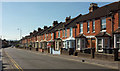
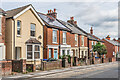
Terrace, Devizes Road, Salisbury
Part of a terrace of 22 dwellings on the southwest side of the A360.
Image: © Derek Harper
Taken: 30 Jun 2018
0.00 miles
2
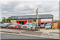
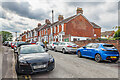
Sartins Garage
Used car dealership on Devizes Road. Until the first part of the 20th Century this was the site of Fisherton Farm.
Image: © Ian Capper
Taken: 22 Sep 2022
0.04 miles
3

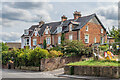
Houses in Palmer Road, with tennis courts below
Image: © David Martin
Taken: 6 Mar 2022
0.05 miles
4
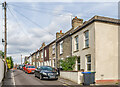
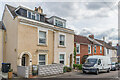
181 - 189 Devizes Road
19th Century terrace, marked on the 1881 1:500 Plan as Castleview Terrace.
Image: © Ian Capper
Taken: 22 Sep 2022
0.05 miles
5
Highfield Road
Cul-de-sac off Devizes Road marked on the 1881 1:500 Plan (when it was named as Highfield).
Image: © Ian Capper
Taken: 22 Sep 2022
0.06 miles
6
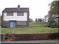
Devizes Road
Early 20th Century housing, first marked on the 1926 25 inch map.
Image: © Ian Capper
Taken: 22 Sep 2022
0.06 miles
7
Bedford Road
Early 20th Century housing cul-de-sac off Devizes Road, first marked on the 1926 25 inch map. Prior to this, the area was a "Brick, Lime and Whiting Works".
Image: © Ian Capper
Taken: 22 Sep 2022
0.07 miles
8
Highfield Road
Cul-de-sac off Devizes Road marked on the 1881 1:500 Plan (when it was named as Highfield). The nearest pair of houses, larger than the terraced housing that makes up the majority of the road, were named Highfield Villas on that map.
Image: © Ian Capper
Taken: 22 Sep 2022
0.07 miles
9

Devizes Road
Early 20th Century terraced housing, first marked on the 1926 25 inch map.
Image: © Ian Capper
Taken: 22 Sep 2022
0.07 miles
10
Covered reservoir
The higher ground on the Devizes Road makes for an ideal location for the installation of a reservoir. The site dates from the latter part of the 1800s but the boarded 'house' is clearly post-war. See Image] for the building to the right of shot.
Image: © Neil Owen
Taken: 27 Oct 2014
0.08 miles