IMAGES TAKEN NEAR TO
Glenmore Business Park, Telford Road, SALISBURY, SP2 7GH
Introduction
This page details the photographs taken nearby to Glenmore Business Park, Telford Road, SP2 7GH by members of the Geograph project.
The Geograph project started in 2005 with the aim of publishing, organising and preserving representative images for every square kilometre of Great Britain, Ireland and the Isle of Man.

There are currently over 7.5m images from over14,400 individuals and you can help contribute to the project by visiting https://www.geograph.org.uk
Image Map
Images are licensed for reuse under creativecommons.org/licenses/by-sa/2.0
Notes
- Clicking on the map will re-center to the selected point.
- The higher the marker number, the further away the image location is from the centre of the postcode.
Image Listing (14 Images Found)
Images are licensed for reuse under creativecommons.org/licenses/by-sa/2.0
Image
Details
Distance
1

Car Dealership, Churchfields
This Toyota dealer is on an large industrial estate tucked away just west of the city between the railway line and a large loop in the River Avon.
Image: © Nigel Mykura
Taken: 30 Oct 2010
0.10 miles
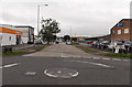
2
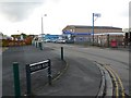
Telford Rd Salisbury
Approximately one mile west of the city centre is Churchfields Industrial Estate where many of the roads are named after great British engineers. Telford Rd runs between Stephenson St and Brunel Rd.
Image: © Nigel Mykura
Taken: 30 Oct 2010
0.10 miles
3
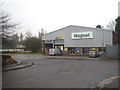
Magnet Joinery depot on Churchfields Industrial Estate
Magnet is a national chain of joinery products suppliers to the trade.
Image: © Rod Allday
Taken: 7 Mar 2013
0.14 miles
4
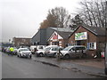
Small industrial units on Churchfields Industrial Estate
Image: © Rod Allday
Taken: 7 Mar 2013
0.14 miles
6

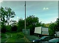
Farm Lane, Salisbury
Looking south from the T-junction with Lower Road and Churchfields Road. The large notice on the right states that this is a private road - no public right of way - access only. No parking. No turning.
Image: © Jaggery
Taken: 21 Sep 2013
0.15 miles
7

Stephenson Road, Salisbury
Looking south from Churchfields Road. Salisbury Furniture Shop http://www.geograph.org.uk/photo/4046990 is on the left,
SCATS Countrystores http://www.geograph.org.uk/photo/4046928 on the right.
Image: © Jaggery
Taken: 21 Sep 2013
0.20 miles
8
South along Brunel Road, Salisbury
Part of Churchfields Industrial Estate. Viewed from Lower Road.
Image: © Jaggery
Taken: 21 Sep 2013
0.21 miles
9
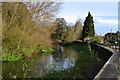
Flood defences on River Avon, west of Salisbury
When full, the level of the river would appear to be at least 2 metres above the adjacent residential street at this point.
Image: © David Martin
Taken: 10 Nov 2012
0.21 miles
10
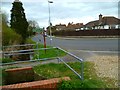
The Orange Way in Wiltshire (165)
The footpath reaches Middle Street in Harnham.
Image: © Shazz
Taken: 22 Apr 2013
0.23 miles