IMAGES TAKEN NEAR TO
Jay Rise, SALISBURY, SP2 7FL
Introduction
This page details the photographs taken nearby to Jay Rise, SP2 7FL by members of the Geograph project.
The Geograph project started in 2005 with the aim of publishing, organising and preserving representative images for every square kilometre of Great Britain, Ireland and the Isle of Man.

There are currently over 7.5m images from over14,400 individuals and you can help contribute to the project by visiting https://www.geograph.org.uk
Image Map
Images are licensed for reuse under creativecommons.org/licenses/by-sa/2.0
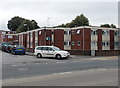
Notes
- Clicking on the map will re-center to the selected point.
- The higher the marker number, the further away the image location is from the centre of the postcode.
Image Listing (114 Images Found)
Images are licensed for reuse under creativecommons.org/licenses/by-sa/2.0
Image
Details
Distance
1
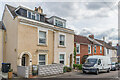
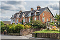
Highfield Road
Cul-de-sac off Devizes Road marked on the 1881 1:500 Plan (when it was named as Highfield). The nearest pair of houses, larger than the terraced housing that makes up the majority of the road, were named Highfield Villas on that map.
Image: © Ian Capper
Taken: 22 Sep 2022
0.05 miles
2
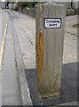
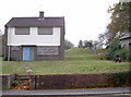
Too close for comfort
A new crossing point was installed in Highbury Avenue just a short distance from the entrance to the school here. Within a fortnight, a concrete mixer vehicle clouted it as it made its way to the new housing estate that is being built nearby. The large wooden post was damaged and uprooted from the ground - hence the fresh tarmac. There are no reports of any injuries.
Image: © Neil Owen
Taken: 27 Oct 2014
0.05 miles
3
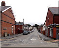
Highbury Avenue, Salisbury
Looking NNE across the A36 Wilton Road. Spire Memorials shop http://www.geograph.org.uk/photo/3939070 is on the right.
Image: © Jaggery
Taken: 21 Sep 2013
0.06 miles
4
Highfield Road
Cul-de-sac off Devizes Road marked on the 1881 1:500 Plan (when it was named as Highfield).
Image: © Ian Capper
Taken: 22 Sep 2022
0.07 miles
5
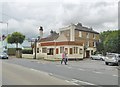
Westwood House and Finchley Road sheltered housing, Salisbury
Viewed across the A36 Wilton Road opposite the Horse & Groom. http://www.geograph.org.uk/photo/3939043
Image: © Jaggery
Taken: 21 Sep 2013
0.10 miles
6
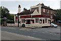
Horse & Groom in Salisbury
Pub and restaurant on the corner of the A36 Wilton Road and Finchley Road.
Image: © Jaggery
Taken: 21 Sep 2013
0.11 miles
7
Salisbury, Horse & Groom
Public house on Wilton Road. Counter left, bar front, restaurant back; games machine, TV, background music, garden. No cask ale on offer at my visit.
Image: © Mike Faherty
Taken: 22 Jul 2017
0.11 miles
8
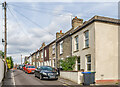
Terrace, Devizes Road, Salisbury
Part of a terrace of 22 dwellings on the southwest side of the A360.
Image: © Derek Harper
Taken: 30 Jun 2018
0.11 miles
9
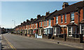
181 - 189 Devizes Road
19th Century terrace, marked on the 1881 1:500 Plan as Castleview Terrace.
Image: © Ian Capper
Taken: 22 Sep 2022
0.11 miles
10
Covered reservoir
The higher ground on the Devizes Road makes for an ideal location for the installation of a reservoir. The site dates from the latter part of the 1800s but the boarded 'house' is clearly post-war. See Image] for the building to the right of shot.
Image: © Neil Owen
Taken: 27 Oct 2014
0.12 miles