IMAGES TAKEN NEAR TO
Highbury Avenue, SALISBURY, SP2 7EY
Introduction
This page details the photographs taken nearby to Highbury Avenue, SP2 7EY by members of the Geograph project.
The Geograph project started in 2005 with the aim of publishing, organising and preserving representative images for every square kilometre of Great Britain, Ireland and the Isle of Man.

There are currently over 7.5m images from over14,400 individuals and you can help contribute to the project by visiting https://www.geograph.org.uk
Image Map (Loading...)


Getting Data...Please wait
Leaflet Map data © OpenStreetMap
Images are licensed for reuse under creativecommons.org/licenses/by-sa/2.0
Notes
- Clicking on the map will re-center to the selected point.
- The higher the marker number, the further away the image location is from the centre of the postcode.
Image Listing (93 Images Found)
Images are licensed for reuse under creativecommons.org/licenses/by-sa/2.0
Image
Details
Distance
1
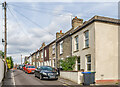
Highfield Road
Cul-de-sac off Devizes Road marked on the 1881 1:500 Plan (when it was named as Highfield).
Image: © Ian Capper
Taken: 22 Sep 2022
0.04 miles
2
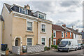
Highfield Road
Cul-de-sac off Devizes Road marked on the 1881 1:500 Plan (when it was named as Highfield). The nearest pair of houses, larger than the terraced housing that makes up the majority of the road, were named Highfield Villas on that map.
Image: © Ian Capper
Taken: 22 Sep 2022
0.04 miles
3
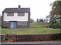
Covered reservoir
The higher ground on the Devizes Road makes for an ideal location for the installation of a reservoir. The site dates from the latter part of the 1800s but the boarded 'house' is clearly post-war. See Image] for the building to the right of shot.
Image: © Neil Owen
Taken: 27 Oct 2014
0.06 miles
4
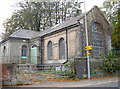
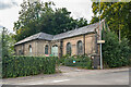
Water pumping station
Former water pumping station on Devizes Road, dating from c.1850. Grade II listed - see https://historicengland.org.uk/listing/the-list/list-entry/1355823?section=official-list-entry. For a closer views see Image The house on the left dates for the c.1960s. Since falling out of use, the site has seen various proposals for conversion into housing.
Image: © Ian Capper
Taken: 22 Sep 2022
0.06 miles
5
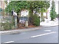
Water Pumping Station, Devizes Road, Salisbury
Pretty much the same as Image, with the addition of some plastic barriers at the entrance, but an opportunity to link to the listed building description at https://www.historicengland.org.uk/listing/the-list/list-entry/1355823 : "Circa 1850, 1 storey raised on plinth grey brick. L plan." Viewed across the A30 Devizes Road.
Image: © Derek Harper
Taken: 30 Jun 2018
0.06 miles
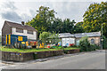
6
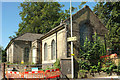
Fisherton Water Works
A modern brick building on the Devizes Road actually dates from the mid/late-1800s. It is part of the site that includes a covered reservoir and various pipes and valves. The site was open fields in the past, with a few prehistoric, Iron Age and Roman discovered. In 1866 some human remains were discovered close by and at the time a number of industries were started up; the local soil is chalky and hence there were chalk pits and brick kilns that flourished in the latter 1800s, but were largely finished by the turn of the century.
See Image] for a view of some of the pipework.
Image: © Neil Owen
Taken: 27 Oct 2014
0.06 miles
7
Milestone, Devizes Road
Milestone beside the A36, Devizes Road.
Image: © Maigheach-gheal
Taken: 12 Jan 2010
0.06 miles
8
Water pumping station
Former water pumping station on Devizes Road, the original section 0n the left dating from c.1850 as part of the Fisherton Water Works with the extension on the right added in the early 20th Century. Grade II listed - see https://historicengland.org.uk/listing/the-list/list-entry/1355823?section=official-list-entry. Since falling out of use in 2014, the site has seen various proposals for conversion into housing.
Image: © Ian Capper
Taken: 22 Sep 2022
0.06 miles
9
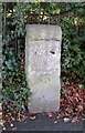
Old Milestone by the A360, Devizes Road, Bemerton, Salisbury
Stone post (plate lost) by the A360, in parish of SALISBURY (SALISBURY District), Devizes Road, Bemerton; opposite No.224, by the road, on West side of road. Salisbury plate, erected by the Fisherton, Wilton, Heytesbury, Willoughby Hedge & Redhone turnpike trust in the 19th century.
Inscription once read:-
(Devizes)
(22)
(Salisbury
(1)
Carved benchmark lower front.
Milestone Society National ID: WI_DZSA22.
Image: © M Faherty
Taken: 20 Jan 2007
0.06 miles
10
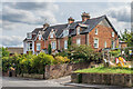
181 - 189 Devizes Road
19th Century terrace, marked on the 1881 1:500 Plan as Castleview Terrace.
Image: © Ian Capper
Taken: 22 Sep 2022
0.07 miles