IMAGES TAKEN NEAR TO
SP2 2HB
Introduction
This page details the photographs taken nearby to SP2 2HB by members of the Geograph project.
The Geograph project started in 2005 with the aim of publishing, organising and preserving representative images for every square kilometre of Great Britain, Ireland and the Isle of Man.

There are currently over 7.5m images from over14,400 individuals and you can help contribute to the project by visiting https://www.geograph.org.uk
Image Map
Images are licensed for reuse under creativecommons.org/licenses/by-sa/2.0
Notes
- Clicking on the map will re-center to the selected point.
- The higher the marker number, the further away the image location is from the centre of the postcode.
Image Listing (671 Images Found)
Images are licensed for reuse under creativecommons.org/licenses/by-sa/2.0
Image
Details
Distance
1
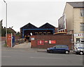
Salisbury Sorting Office
Located opposite Salisbury railway station. A white arrow points right towards the enquiry office. Though many other sorting offices are now called delivery offices, the nameplate here in September 2013 shows Salisbury Sorting Office.
Image: © Jaggery
Taken: 21 Sep 2013
0.02 miles
2
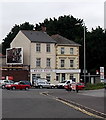
Bevan House, Salisbury
Located at 148 Fisherton Street, next door to Salisbury Sorting Office, http://www.geograph.org.uk/photo/3938421 Bevan House is the registered office of Salisbury Trust for the Homeless which provides a home for single adults who would otherwise have nowhere to live.
Image: © Jaggery
Taken: 21 Sep 2013
0.03 miles
3
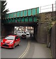
Fisherton Street railway bridge, Salisbury
About 100 metres east of Salisbury railway station. Headroom under the bridge is shown as 14' 3".
Image: © Jaggery
Taken: 21 Sep 2013
0.03 miles
4
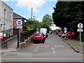
One-way street to Spire View, Salisbury
From Fisherton Street past the edge of Salisbury Delivery Office. Red Royal Mail vans are parked on the right.
Image: © Jaggery
Taken: 9 May 2015
0.03 miles
5
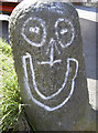
Smiling stone
An amusingly painted stone bollard in front of the old railway buildings on Fisherton Street, west of the bridge.
Image: © Neil Owen
Taken: 28 Mar 2012
0.04 miles
6
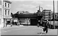
Fisherton Street, Salisbury 1986 (2)
The view southeast near the railway station at the western end of this prominent Salisbury thoroughfare, that is the main point of entry to the city from the west. Compare this view to the one taken in June 1908 from the same viewpoint, on the occasion of King Edward's visit to the city. https://media.geograph.org.uk/files/7eabe3a1649ffa2b3ff8c02ebfd5659f/008b_Fisherton_Street_West_-original.jpg
Image
Image: © Mike Searle
Taken: Unknown
0.04 miles
7
Railway bridge over Fisherton Street, Salisbury
Image: © JThomas
Taken: 13 Jul 2019
0.04 miles
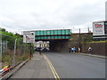
8
![Salisbury bridges [10]](https://s1.geograph.org.uk/geophotos/06/39/46/6394697_75bc1b65_120x120.jpg)
Salisbury bridges [10]
This bridge carries the railway over Fisherton Street. The bridge was strengthened in December 2019. Salisbury station is just a few yards to the left.
A cathedral was established at the Iron Age hillfort of Old Sarum by the Normans. In 1220 the cathedral was removed to the nearby plain and New Sarum (Salisbury) grew up around it, receiving a city charter in 1227. Located at the confluence of five rivers (Avon, Nadder, Ebble, Wylye and Bourne) the city is prone to flooding. Traffic between the ports of Southampton and Bristol, passes around the city's ring-road via the A36 causing much congestion.
Image: © Michael Dibb
Taken: 31 Dec 2019
0.04 miles
9
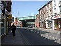
Salisbury, railway bridge
Railway bridge over Fisherton Street, just East of the railway station.
Image: © Mike Faherty
Taken: 1 Apr 2009
0.04 miles
10
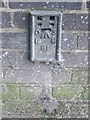
Flush Bracket 61, Salisbury Railway Bridge
The flush bracket is to be found under railway bridge E4/236/BAE1 which takes the railway over Fisherton Street. For a photograph of the railway bridge Image and for further information on the bracket http://www.bench-marks.org.uk/bm9475
A bench mark is an Ordnance Survey arrowhead sign found on walls, bridges, churches and specially erected triangulation pillars where the altitude above sea-level has been accurately measured by surveyors. The arrowhead points to a horizontal line above it which marks the exact altitude.
With rivets and pivots there is no datum (horizontal line) cut, the pointed-to horizontal surface defining the datum height.
Image: © Maigheach-gheal
Taken: 13 Jun 2010
0.04 miles