IMAGES TAKEN NEAR TO
Castle Lane, SALISBURY, SP2 0HG
Introduction
This page details the photographs taken nearby to Castle Lane, SP2 0HG by members of the Geograph project.
The Geograph project started in 2005 with the aim of publishing, organising and preserving representative images for every square kilometre of Great Britain, Ireland and the Isle of Man.

There are currently over 7.5m images from over14,400 individuals and you can help contribute to the project by visiting https://www.geograph.org.uk
Image Map (Loading...)


Getting Data...Please wait
Leaflet Map data © OpenStreetMap
Images are licensed for reuse under creativecommons.org/licenses/by-sa/2.0
Notes
- Clicking on the map will re-center to the selected point.
- The higher the marker number, the further away the image location is from the centre of the postcode.
Image Listing (433 Images Found)
Images are licensed for reuse under creativecommons.org/licenses/by-sa/2.0
Image
Details
Distance
2
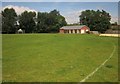
New pavilion, Castle Meadow, Wilton
The brick pavilion, opened in July 2012, is to the north of the former wooden pavilion which has been demolished.
Image: © Derek Harper
Taken: 19 Jun 2014
0.04 miles
3
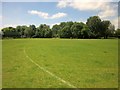
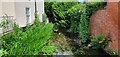
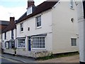
Castle Meadow, Wilton
This playing field has been levelled and re-seeded in recent years. The trees are along a channel of the River Wylye.
Image: © Derek Harper
Taken: 19 Jun 2014
0.04 miles
4
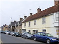
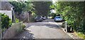
North Street, Wilton
The street is mainly residential at its northerly end. The cream house has a firemark on it. For a view of the mark Image
Image: © Maigheach-gheal
Taken: 28 Mar 2011
0.04 miles
5
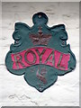
Firemark, North Street
Firemarks originated around the late 17th century at which time insurance companies operated their own fire brigades to protect insured property. As many buildings did not have a formal address until the advent of the postal system, insurance companies identified insured properties by placing a mark on the outside wall of the buildings.
Image: © Maigheach-gheal
Taken: 28 Mar 2011
0.04 miles
6
![Wilton houses [9]](https://s2.geograph.org.uk/geophotos/07/04/46/7044602_47a36c76_120x120.jpg)
Wilton houses [9]
Odd numbers 55 to 65 North Street are a row of 6 almshouses type cottages. Built between 1844 and 1859 in gault brick on a red brick plinth under a slate roof. Listed, grade II, with details at: https://historicengland.org.uk/listing/the-list/list-entry/1023724
A former county town, Wilton is situated some 2¾ miles west of Salisbury on the confluence of the River Nadder and the River Wylye. The town grew around Wilton Abbey, founded in the 8th century, and was the administrative capital of Wiltshire until the 11th century. The town declined in importance after Salisbury Cathedral was built. The town is renowned for carpet manufacture, which began in 1741 when two French weavers were brought in and a carpet factory continued to operate until 1995. The country estate of Wilton House is an integral part of the town.
Image: © Michael Dibb
Taken: 25 Aug 2021
0.04 miles
7
![Wilton houses [8]](https://s2.geograph.org.uk/geophotos/07/04/38/7043810_ab9dba16_120x120.jpg)
Wilton houses [8]
Odd numbers 67 to 75 North Street are a row of five cottages, with numbers 73 and 75 a different build. Number 67 has a late 19th century shopfront. Constructed of painted brick under a tile roof. Listed, grade II, with details at: https://historicengland.org.uk/listing/the-list/list-entry/1023725
A former county town, Wilton is situated some 2¾ miles west of Salisbury on the confluence of the River Nadder and the River Wylye. The town grew around Wilton Abbey, founded in the 8th century, and was the administrative capital of Wiltshire until the 11th century. The town declined in importance after Salisbury Cathedral was built. The town is renowned for carpet manufacture, which began in 1741 when two French weavers were brought in and a carpet factory continued to operate until 1995. The country estate of Wilton House is an integral part of the town.
Image: © Michael Dibb
Taken: 25 Aug 2021
0.04 miles
8
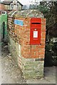
Wilton: postbox № SP2 16, North Street
Quite a common sight is a postbox set within a wall, but in the end of a wall it is more unusual.
Image: © Chris Downer
Taken: Unknown
0.05 miles
9
Dentist, Wilton
Dental surgery on North Street. There is a bench mark on the building angle with Albany Terrace. For a view of the bench mark Image
Image: © Maigheach-gheal
Taken: 12 May 2010
0.07 miles