IMAGES TAKEN NEAR TO
Campbell Road, SALISBURY, SP1 3BQ
Introduction
This page details the photographs taken nearby to Campbell Road, SP1 3BQ by members of the Geograph project.
The Geograph project started in 2005 with the aim of publishing, organising and preserving representative images for every square kilometre of Great Britain, Ireland and the Isle of Man.

There are currently over 7.5m images from over14,400 individuals and you can help contribute to the project by visiting https://www.geograph.org.uk
Image Map
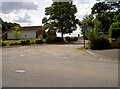
Images are licensed for reuse under creativecommons.org/licenses/by-sa/2.0
Notes
- Clicking on the map will re-center to the selected point.
- The higher the marker number, the further away the image location is from the centre of the postcode.
Image Listing (66 Images Found)
Images are licensed for reuse under creativecommons.org/licenses/by-sa/2.0
Image
Details
Distance
1
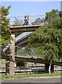
Salisbury - after Escher
The footbridge over the A36 (Churchill Way North) as seen from Wyndham Road.
Image: © Neil Owen
Taken: 23 Sep 2013
0.07 miles
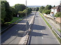
2
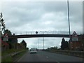
Footbridge over A36
This bridge provides a link across the dual carriageway. The road (Churchill Way North) closed a link between the streets on each side.
Image: © David Smith
Taken: 22 Jun 2013
0.07 miles
3
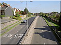
Churchill Way North
Actually looking more eastwards along the A36 to the St Mark's Roundabout. See Image] for the opposite view.
Image: © Neil Owen
Taken: 23 Sep 2013
0.08 miles
4
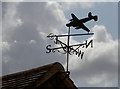
A silhouette against the sky
A weathervane on a garage in Netheravon Road, presumably belonging to an old flier. The outline suggests it's an Avro Shackleton, but does anyone have other opinions?
Image: © Neil Owen
Taken: 4 Aug 2014
0.09 miles
5
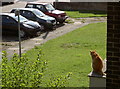
Who's that on my patch?
A ginger moggie, perched on the balcony of a first floor flat, spots another feline in the road below. Many minutes of fierce staring followed.
Image: © Neil Owen
Taken: 23 Sep 2013
0.09 miles
6
Churchill Way North
Looking from the footbridge as the A36 runs towards the Castle Roundabout. See Image] for an opposing view.
Image: © Neil Owen
Taken: 23 Sep 2013
0.10 miles
7
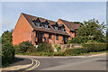
Tower Mews
Cul de sac of town houses off St Mark's Avenue, completed in 1997.
Image: © Ian Capper
Taken: 22 Sep 2022
0.10 miles
8
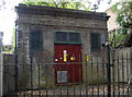
On top of the line
An electricity substation on St Mark's Avenue, and situated above a railway tunnel.
Image: © Neil Owen
Taken: 4 Aug 2014
0.11 miles
9
Netheravon Road
This is an unadopted road - meaning the local council highways department do not look after it, hence the change from tarmac to loose gravel.
Image: © Neil Owen
Taken: 4 Aug 2014
0.12 miles
10
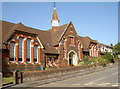
Wylye House
This care home now occupies a former school. Built in 1889, the Gothic style St Mark's school catered for local children from the age of five upwards. In 1926 it opened it doors as an Infant and Junior School; by 1961 the older children were moved to another premise in Somerset Road, and in 1990 the last of the pupils left for new buildings.
Image: © Neil Owen
Taken: 23 Sep 2013
0.13 miles