1
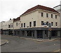
Ronald takes over
A more contemporary building in Winchester Street, dating to 1926, now another takeaway for the perfidious burger vendor.
Image: © Neil Owen
Taken: 23 Sep 2013
0.01 miles
2
Winchester Street
Image: © Oast House Archive
Taken: 26 Aug 2013
0.01 miles
3
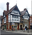
Cross Keys House, Queen Street, Salisbury
Grade II city centre building erected in 1878 to a design by architect Henry Hall. Description at this https://historicengland.org.uk/listing/the-list/list-entry/1258721. Retail and office accommodation.
Illustrated in the Building News magazine of 6 September 1878, with this accompanying text: "The illustration shows the banking premises now erecting at Salisbury for Messrs. Pinckney Brothers. The building is constructed with Fareham red bricks and Bath stone dressings. The timber-work is of oak, with incised plaster in the panels. The banking.room is 20ft. high, and is lighted by the large bay window, which will be partly filled with stained glass illustrating some of the guilds for which Salisbury was formerly celebrated. The remainder of the ground floor is appropriated to the clerks and private rooms; a large strong-room and book- rooms are also on this floor. The upper part contains the residence of the manager. The works are now being carried out by Messrs. Hale and Sons, of Salisbury, under the direction of Mr. Henry Hall, architect, of 19, Doughty-street, Mecklenburg-square, London."
Image: © Jim Osley
Taken: 13 Jul 2017
0.02 miles
4
Brown Street
Image: © Oast House Archive
Taken: 26 Aug 2013
0.03 miles
5
Salisbury bus station
Some quite long-distance routes start from here, an example being the X3 to Bournemouth.
Image: © Dr Neil Clifton
Taken: 10 Jun 2000
0.03 miles
6
Shop to let, Endless Street, Salisbury
Viewed across Blue Boar Row in September 2013. The British History website states that Endless Street, which formed the northern part of the early High Street, originally extended as far south as Milford Street, thus taking in the section skirting the Market Place, now called Queen Street. The name, in use from the 14th century, was perhaps given to the street in contrast to those further east whose northern ends extended no further than Bedwin Street.
Image: © Jaggery
Taken: 21 Sep 2013
0.03 miles
7
Cross Keys House, Salisbury
Office building at 22 Queen Street, on the corner of Winchester Street.
The building is an odd mixture of styles, with a brick ground floor and
quasi-medieval upper part. It is Victorian, dating from 1878.
Image: © Jaggery
Taken: 21 Sep 2013
0.03 miles
8
Cross Keys House, Salisbury
What looks like a Tudor building on the north-east corner of the market place is actually a Victorian 'sham' from 1878, but is nevertheless listed grade 2 for its interesting architecture (list entry 1258721). Originally a bank, now home to various small businesses.
Image: © Stephen Craven
Taken: 26 Sep 2018
0.03 miles
9
Bench Mark, Cross Keys House
The bench mark is to be found on Cross Keys House (#21 Queen Street). For a wider view
Image and for more information about the bench mark http://www.bench-marks.org.uk/bm34677
A bench mark is an Ordnance Survey arrowhead sign found on walls, bridges, churches and specially erected triangulation pillars where the altitude above sea-level has been accurately measured by surveyors. The arrowhead points to a horizontal line above it which marks the exact altitude.
With rivets and pivots there is no datum (horizontal line) cut, the pointed-to horizontal surface defining the datum height.
Image: © Maigheach-gheal
Taken: 17 Jun 2010
0.03 miles
10
Benchmark and street name sign on Cross Keys House
The Ordnance Survey cut mark benchmark, ringed in white paint, is described on the Bench Mark Database at http://www.bench-marks.org.uk/bm34677
Image: © Roger Templeman
Taken: 5 Nov 2011
0.03 miles


