IMAGES TAKEN NEAR TO
Scholars Close, ANDOVER, SP11 9TS
Introduction
This page details the photographs taken nearby to Scholars Close, SP11 9TS by members of the Geograph project.
The Geograph project started in 2005 with the aim of publishing, organising and preserving representative images for every square kilometre of Great Britain, Ireland and the Isle of Man.

There are currently over 7.5m images from over14,400 individuals and you can help contribute to the project by visiting https://www.geograph.org.uk
Image Map (Loading...)


Getting Data...Please wait
Leaflet Map data © OpenStreetMap
Images are licensed for reuse under creativecommons.org/licenses/by-sa/2.0
Notes
- Clicking on the map will re-center to the selected point.
- The higher the marker number, the further away the image location is from the centre of the postcode.
Image Listing (20 Images Found)
Images are licensed for reuse under creativecommons.org/licenses/by-sa/2.0
Image
Details
Distance
1
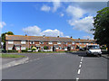
Central Street, Ludgershall
Houses at the junction of Dewey's Lane (left), Crawlboy's Lane (right) and Central Street, on which I was standing. A couple of St George's flags are being flown in honour of England's disappointing World Cup campaign.
Image: © Andrew Smith
Taken: 20 Jun 2010
0.08 miles
2
Ludgershall, Fleming Close
1960s bungalows, off Central Street.
Image: © Mike Faherty
Taken: 16 Mar 2010
0.10 miles
3
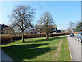
Small green on Short Street, Ludgershall
Image: © Robin Webster
Taken: 20 Mar 2015
0.10 miles
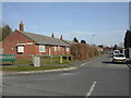
4
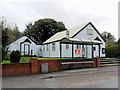
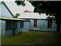
Ludgershall Mission Hall
Corrugated church building on Andover Road.
Image: © Mike Faherty
Taken: 16 Mar 2010
0.11 miles
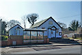
5
Ludgershall Mission Hall
Such 'tin huts' are rarer now, but I understand that some have thankfully been listed.
Image: © nick macneill
Taken: 15 Oct 2012
0.11 miles
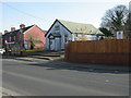
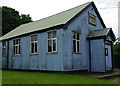
6
Ludgershall Mission Hall
Corrugated iron, with a similar but smaller building set back to the left.
Image: © Robin Webster
Taken: 20 Mar 2015
0.12 miles
8
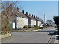
Houses on Short Street
An odd name for a road on a housing estate that is not very short and not much resembling the usual concept of 'street'. The explanation seems to be that earlier on in housing development to the west the street was indeed short and a dead-end. It was then extended to the east into newer development.
Image: © Robin Webster
Taken: 20 Mar 2015
0.15 miles
9
Ludgershall - Mission Hall
During the Second World War the hall was taken over by the Open Air mission and again used as a 'Soldiers' welcome'.
Image: © Chris Talbot
Taken: 19 May 2008
0.16 miles
10
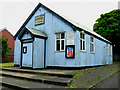
Ludgershall - Mission Hall
This mission hall was opened in 1904. During the First World War the hall was opened up to all troops in the area and was known as the 'Soldiers' Welcome'. Refreshments, entertainments, games and writing materials were all provided free of charge.
Image: © Chris Talbot
Taken: 19 May 2008
0.16 miles