IMAGES TAKEN NEAR TO
Bird Field, EASTLEIGH, SO53 4NY
Introduction
This page details the photographs taken nearby to Bird Field, SO53 4NY by members of the Geograph project.
The Geograph project started in 2005 with the aim of publishing, organising and preserving representative images for every square kilometre of Great Britain, Ireland and the Isle of Man.

There are currently over 7.5m images from over14,400 individuals and you can help contribute to the project by visiting https://www.geograph.org.uk
Image Map
Images are licensed for reuse under creativecommons.org/licenses/by-sa/2.0
Notes
- Clicking on the map will re-center to the selected point.
- The higher the marker number, the further away the image location is from the centre of the postcode.
Image Listing (14 Images Found)
Images are licensed for reuse under creativecommons.org/licenses/by-sa/2.0
Image
Details
Distance
1
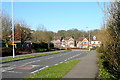
Sky's Wood Road
Modern development (since the 1980s). This is part of Valley Park, within Test Valley District but adjacent to and more accessible from the urban area of Chandler's Ford in Eastleigh Borough.
Image: © Graham Horn
Taken: 19 Mar 2011
0.07 miles
2
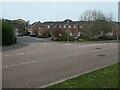
Terraced houses, Jack Close
Off Sky's Wood Road. Part of a housing development on the west side of Chandler's Ford.
Image: © Christine Johnstone
Taken: 8 Nov 2021
0.08 miles
3
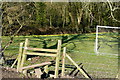
Rural into urban
On today's walk, this was the stile that took me from the rural (the paddock in which I am standing) into the urban (the play ground ahead with houses beyond). Quite a traumatic step.
Image: © Graham Horn
Taken: 19 Mar 2011
0.09 miles
4
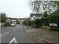
Tolefrey Gardens
Off Sky's Wood Road. Part of a housing development on the west side of Chandler's Ford.
Image: © Christine Johnstone
Taken: 8 Nov 2021
0.09 miles
5
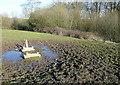
Former feeding area
The muddy approach and the concrete bases give it away; until recently there must have been an animal feeding or drinking trough here.
Image: © Graham Horn
Taken: 19 Mar 2011
0.10 miles
6
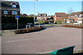
Valley Park
Modern development (since the 1980s). This is part of Valley Park, within Test Valley District but adjacent to and more accessible from the urban area of Chandler's Ford in Eastleigh Borough. I'm intrigued why this road should be called "Morgan le Fay Drive". What link is there with Arthurian legends?
Image: © Graham Horn
Taken: 19 Mar 2011
0.15 miles
7
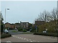
Morgan le Fey Drive, western edge of Chandler's Ford
Named after a powerful enchantress in the Arthurian legends.
Image: © Christine Johnstone
Taken: 8 Nov 2021
0.15 miles
8
Sky's Wood Road, western edge of Chandler's Ford
The main thoroughfare through a large-ish housing development.
Image: © Christine Johnstone
Taken: 8 Nov 2021
0.16 miles
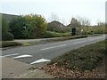
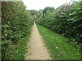
9
Path heading east from Sky's Wood Road
Cutting across a large loop in the road, which is the main thoroughfare in a housing development on the western edge of Chandler's Ford.
Image: © Christine Johnstone
Taken: 8 Nov 2021
0.16 miles
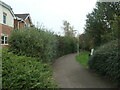
10
Public footpath between Merlin Way and Catmint Close
On the western edge of Chandler's Ford. Heading north-east from Sky's Wood Road towards Knight Wood.
Image: © Christine Johnstone
Taken: 8 Nov 2021
0.18 miles