IMAGES TAKEN NEAR TO
Chalvington Road, EASTLEIGH, SO53 3EH
Introduction
This page details the photographs taken nearby to Chalvington Road, SO53 3EH by members of the Geograph project.
The Geograph project started in 2005 with the aim of publishing, organising and preserving representative images for every square kilometre of Great Britain, Ireland and the Isle of Man.

There are currently over 7.5m images from over14,400 individuals and you can help contribute to the project by visiting https://www.geograph.org.uk
Image Map
Images are licensed for reuse under creativecommons.org/licenses/by-sa/2.0
Notes
- Clicking on the map will re-center to the selected point.
- The higher the marker number, the further away the image location is from the centre of the postcode.
Image Listing (11 Images Found)
Images are licensed for reuse under creativecommons.org/licenses/by-sa/2.0
Image
Details
Distance
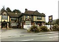
4
Chandler's Ford, The Hut
Beefeater pub and restaurant on Bournemouth Road, named after a once-nearby farm. Internally, the pub half has a back bar with drinking and eating space front; subdued lighting and colour scheme, background music, games machines, terrace. Cask ale on offer at my visit: Marston's Pedigree.
Image: © Mike Faherty
Taken: 21 Apr 2012
0.22 miles
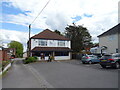
5
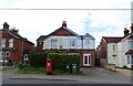
Houses on Bournemouth Road, Chandler's Ford
Showing position of Postbox No. SO53 175.
See Image] for postbox.
Image: © JThomas
Taken: 25 Apr 2022
0.22 miles
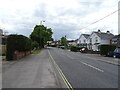
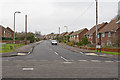
6
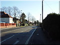
Leigh Road, Eastleigh
Leigh Road (A335) runs straight through the middle of this grid square and is the main road between Eastleigh and Chandlers Ford. The Chandlers Ford end of the road, pictured here, is almost entirely populated by 1930s suburban houses.
Image: © GaryReggae
Taken: 29 Jan 2006
0.23 miles
7
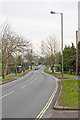
Looking along Leigh Road, Eastleigh
From its junction with Falkland Road. The sinuous shape of the road is only apparent on large scale maps.
Image: © Peter Facey
Taken: 27 Jan 2009
0.24 miles
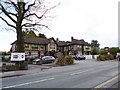
8
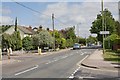
Junction of Bournemouth Road and Brickfield Lane, Chandler's Ford
Brickfield Lane is at left and provides access to Chandler's Ford Industrial Estate. Keble Road is in right foreground. The grid line runs along the base of the picture.
Image: © Peter Facey
Taken: 28 Jun 2008
0.24 miles
9
Westfield Road, Eastleigh
Looking across Falkland Road.
Image: © Peter Facey
Taken: 27 Jan 2009
0.25 miles
10
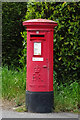
Elizabeth II postbox on Bournemouth Road, Chandler's Ford
Postbox No. SO22 53.
See Image] for context.
Image: © JThomas
Taken: 25 Apr 2022
0.25 miles