IMAGES TAKEN NEAR TO
Duttons Road, ROMSEY, SO51 8FR
Introduction
This page details the photographs taken nearby to Duttons Road, SO51 8FR by members of the Geograph project.
The Geograph project started in 2005 with the aim of publishing, organising and preserving representative images for every square kilometre of Great Britain, Ireland and the Isle of Man.

There are currently over 7.5m images from over14,400 individuals and you can help contribute to the project by visiting https://www.geograph.org.uk
Image Map
Images are licensed for reuse under creativecommons.org/licenses/by-sa/2.0
Notes
- Clicking on the map will re-center to the selected point.
- The higher the marker number, the further away the image location is from the centre of the postcode.
Image Listing (153 Images Found)
Images are licensed for reuse under creativecommons.org/licenses/by-sa/2.0
Image
Details
Distance
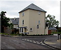
1
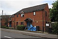
Little Gem Children, Romsey
The name board on the wooden gate at 75 Duttons Road states
that Little Gem Children is an Ofsted registered childminder.
Image: © Jaggery
Taken: 31 May 2015
0.01 miles
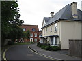
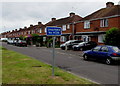
2
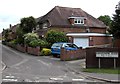
Lansdowne Close, Romsey
Numbers 19-29 Lansdowne Close ahead are set back from Duttons Road. Numbers 1-18 http://www.geograph.org.uk/photo/4502889 are alongside it.
Image: © Jaggery
Taken: 31 May 2015
0.03 miles
3
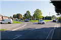
Road Junction on Duttons Road
With Malmesbury Road left, and Princes Road right.
Image: © Peter Facey
Taken: 29 Sep 2011
0.04 miles
4
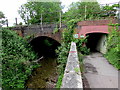
Double bridges on the east side of Duttons Road, Romsey
About 375 metres NW of Romsey railway station, the Wessex Main Line crosses a stream and a path.
The stream bridge looks much older than the path bridge.
Image: © Jaggery
Taken: 31 May 2015
0.05 miles
5
The Ale House, Brewery Lane, Romsey
Recently-built house on the corner of Brewery Lane and Princes Road. A former brewery http://www.geograph.org.uk/photo/611458 is nearby.
Image: © Jaggery
Taken: 31 May 2015
0.05 miles
6
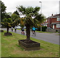
Two exotic trees and four cyclists in Romsey
The cyclists are on the A3057 Malmesbury Road.
Image: © Jaggery
Taken: 31 May 2015
0.06 miles
8
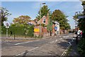
Landsdowne Lodge, 94 Greatbridge Street
Turning to Priestlands on left.
Image: © Peter Facey
Taken: 1 Oct 2011
0.08 miles
9
Duttons Road south of Malmesbury Road, Romsey
Duttons Road behind the camera is the A3057.
Duttons Road ahead is unclassified and unsuitable for heavy goods vehicles.
Image: © Jaggery
Taken: 31 May 2015
0.09 miles
10
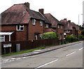
NW side of Lansdowne Close, Romsey
Aligned NW-SE, numbers 1-18 Lansdowne Close are alongside the A3057 Duttons Road.
Numbers 19-29 are aligned SSW-NNE out of shot on the left.
Image: © Jaggery
Taken: 31 May 2015
0.09 miles