IMAGES TAKEN NEAR TO
Mountbatten Avenue, ROMSEY, SO51 8DX
Introduction
This page details the photographs taken nearby to Mountbatten Avenue, SO51 8DX by members of the Geograph project.
The Geograph project started in 2005 with the aim of publishing, organising and preserving representative images for every square kilometre of Great Britain, Ireland and the Isle of Man.

There are currently over 7.5m images from over14,400 individuals and you can help contribute to the project by visiting https://www.geograph.org.uk
Image Map
Images are licensed for reuse under creativecommons.org/licenses/by-sa/2.0
Notes
- Clicking on the map will re-center to the selected point.
- The higher the marker number, the further away the image location is from the centre of the postcode.
Image Listing (275 Images Found)
Images are licensed for reuse under creativecommons.org/licenses/by-sa/2.0
Image
Details
Distance
1
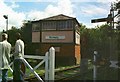
Romsey Signal Box in its new location
Romsey Signal Box was built in 1871 and was originally located on the other side of the railway embankment (just visible on the left of the photo). Resignalling works in 1982 made the box redundant. When BR asked the nearby infants school for access permission to remove the box, the Headteacher had the idea of saving it for education purposes. A trust was formed and bought the box for £10. Moving it into the school grounds cost another £10,000! It is now a listed building and is looked after by The Friends of Romsey Signal Box and is open one Sunday every month. See their website: http://www.romseysignalbox.org.uk/
Image: © Alan Cooper
Taken: 7 Aug 2005
0.03 miles
2
Romsey Division Guide Headquarters
In Baden Powell Way, Romsey, opposite the modern Scout Hall. http://www.geograph.org.uk/photo/4503305
Image: © Jaggery
Taken: 31 May 2015
0.05 miles
3
Baden Powell Way, Romsey
On the east side of Alma Road.
Image: © Jaggery
Taken: 31 May 2015
0.05 miles
4
Dr Peter Centre in Romsey
Completed in autumn 2011, the Dr Peter Centre in Baden Powell Way is the home of Romsey District Scouts and 1st Romsey Scout Group. It replaced the original timber framed scout hut.
Image: © Jaggery
Taken: 31 May 2015
0.06 miles
5
Baden Powell Way electricity substation, Romsey
The SSE Power Distribution electricity substation is inside a wooden enclosure near the Dr Peter Centre. http://www.geograph.org.uk/photo/4503305
Image: © Jaggery
Taken: 31 May 2015
0.06 miles
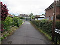
6
Footpath to Timsbury leading off from the Winchester Road
Image: © Basher Eyre
Taken: 19 Feb 2009
0.06 miles
7
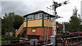
Romsey Signal Box Project
This signal box is not adjacent to the actual railway line, which passes behind on an embankment.
Image: © David Martin
Taken: 30 Sep 2019
0.06 miles
8
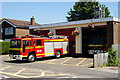
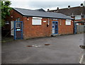
Fire Station, Romsey, Hampshire
Located on Alma Road, with one of the engines gleaming in the bright sunlight.
Image: © Peter Trimming
Taken: 17 Jun 2010
0.07 miles
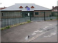
9
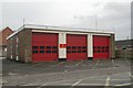
Romsey fire station
Romsey fire station, Alma Road, Romsey, Hampshire
Image: © Kevin Hale
Taken: 11 Nov 2006
0.08 miles
10
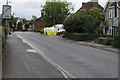
Zone ends signs, Alma Road, Romsey
Marking the end of a no parking or waiting zone. The zone is in force from 8am-6pm every day except Sunday.
Image: © Jaggery
Taken: 31 May 2015
0.08 miles