IMAGES TAKEN NEAR TO
Princes Road, ROMSEY, SO51 8DS
Introduction
This page details the photographs taken nearby to Princes Road, SO51 8DS by members of the Geograph project.
The Geograph project started in 2005 with the aim of publishing, organising and preserving representative images for every square kilometre of Great Britain, Ireland and the Isle of Man.

There are currently over 7.5m images from over14,400 individuals and you can help contribute to the project by visiting https://www.geograph.org.uk
Image Map (Loading...)


Getting Data...Please wait
Leaflet Map data © OpenStreetMap
Images are licensed for reuse under creativecommons.org/licenses/by-sa/2.0
Notes
- Clicking on the map will re-center to the selected point.
- The higher the marker number, the further away the image location is from the centre of the postcode.
Image Listing (499 Images Found)
Images are licensed for reuse under creativecommons.org/licenses/by-sa/2.0
Image
Details
Distance
1
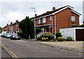
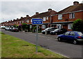
West side of Princes Road, Romsey
Looking towards Station Road.
Image: © Jaggery
Taken: 31 May 2015
0.03 miles
2
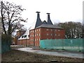
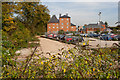
Malthouse in Strong's Brewery conversion, Romsey
On the old Strong's brewery site - the chimneys can still be seen over the houses from the surrounding streets but the glorious smell has long gone. Strong's was taken over by Whitbreads in 1969 and brewing ceased 10 years later.
The building is in Brewery Lane - a new and as yet unlabelled road leading off Princes Road.
Image: © Rosemary Oakeshott
Taken: 13 Nov 2007
0.05 miles
3
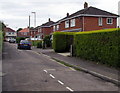
Jubilee Road, Romsey
Looking towards Duttons Road.
Image: © Jaggery
Taken: 31 May 2015
0.05 miles
4
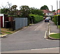
Jubilee Road, Romsey
Viewed across Malmesbury Road. Jubilee Road extends for about 110 metres to Duttons Road.
An electricity substation http://www.geograph.org.uk/photo/4502663 is on the left.
Image: © Jaggery
Taken: 31 May 2015
0.05 miles
6
The Malthouse
A redevelopment of part of the old Strongs Brewery site. (elevated camera position)
Image: © Peter Facey
Taken: 1 Oct 2011
0.06 miles
7
The Malthouse, Brewery Lane
A redevelopment of part of the former Strongs Brewery site as flats. The corner stone of this building is dated 1899.
Image: © Peter Facey
Taken: 2 Oct 2011
0.06 miles
8
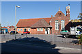
The Library, Princes Road
Side view, seen from Princes Road.
Image: © Peter Facey
Taken: 29 Sep 2011
0.06 miles
9
Duttons Road south of Malmesbury Road, Romsey
Duttons Road behind the camera is the A3057.
Duttons Road ahead is unclassified and unsuitable for heavy goods vehicles.
Image: © Jaggery
Taken: 31 May 2015
0.06 miles
10
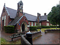
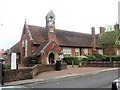
Romsey Boys' National School and Master's House
A school from 1872 to 1957. Became the town's library in 1968.
Image: © John Lucas
Taken: 11 Jul 2017
0.06 miles