IMAGES TAKEN NEAR TO
Gardeners Lane, ROMSEY, SO51 6AD
Introduction
This page details the photographs taken nearby to Gardeners Lane, SO51 6AD by members of the Geograph project.
The Geograph project started in 2005 with the aim of publishing, organising and preserving representative images for every square kilometre of Great Britain, Ireland and the Isle of Man.

There are currently over 7.5m images from over14,400 individuals and you can help contribute to the project by visiting https://www.geograph.org.uk
Image Map
Images are licensed for reuse under creativecommons.org/licenses/by-sa/2.0
Notes
- Clicking on the map will re-center to the selected point.
- The higher the marker number, the further away the image location is from the centre of the postcode.
Image Listing (13 Images Found)
Images are licensed for reuse under creativecommons.org/licenses/by-sa/2.0
Image
Details
Distance
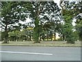
1
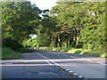
Gardeners Lane
This country lane is a bit of a rat run from the A27 to the A3090 and the M27. Here we're looking south west near the lane's junction with the A3090.
Image: © Peter Jordan
Taken: 21 Jun 2006
0.11 miles
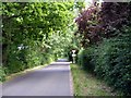
2
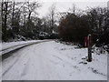
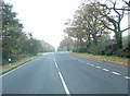
West Wellow: southern end of Gardeners Lane
Looking along this country lane in icy conditions, as it approaches the A3090 (behind us). On the right is Image
Image: © Chris Downer
Taken: 19 Dec 2010
0.14 miles
3
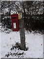
West Wellow: postbox № SO51 532, Gardeners Lane
This little postbox is a short distance from the A3090 crossroads and has scheduled final collection times of 4pm on weekdays and 7am on Saturdays.
Image: © Chris Downer
Taken: 19 Dec 2010
0.15 miles
4
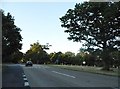
A3090 at junction with Gardeners Lane
This dual carriageway now seems oversized for the traffic it carries - although it soon becomes a rat-run if there are problems on the nearby M27
Image: © David Martin
Taken: 30 May 2008
0.16 miles
5
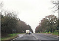
A3090 crossroads
Left is to Ridge and right to Embly where Florence Nightingale lived.
Image: © Stuart Logan
Taken: 16 Nov 2011
0.18 miles
8
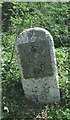
Old Milestone by the A3090, Ranvilles Farm, Romsey Extra parish
Stone post (plate lost) by the A3090, in parish of ROMSEY EXTRA (TEST VALLEY District), Ranvilles Farm; 50m South of farm entrance, on grass verge, on East side of road. Romsey rectangle stone, erected by the Romsey & Ringwood turnpike trust in the 19th century.
Inscription once read:-
(Romsey 2)
(Ringwood 16)
Grade II listed.
List Entry Number: 1093652 https://historicengland.org.uk/listing/the-list/list-entry/1093652
Milestone Society National ID: HA_RORI02.
Image: © K Lawrence
Taken: 26 May 2003
0.19 miles
9
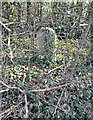
NEW
Old Milestone by the A3090, Ranvilles Farm, Romsey Extra parish
Stone post (plate lost) by the A3090, in parish of ROMSEY EXTRA (TEST VALLEY District), Ranvilles Farm; 50m South of farm entrance, on grass verge, on East side of road. Romsey rectangle stone, erected by the Romsey & Ringwood turnpike trust in the 19th century.
Inscription once read:-
(Romsey 2)
(Ringwood 16)
Grade II listed.
List Entry Number: 1093652 https://historicengland.org.uk/listing/the-list/list-entry/1093652
Milestone Society National ID: HA_RORI02.
Image: © Paul Hamilton
Taken: 10 Mar 2025
0.19 miles