IMAGES TAKEN NEAR TO
Tadburn Road, ROMSEY, SO51 5AX
Introduction
This page details the photographs taken nearby to Tadburn Road, SO51 5AX by members of the Geograph project.
The Geograph project started in 2005 with the aim of publishing, organising and preserving representative images for every square kilometre of Great Britain, Ireland and the Isle of Man.

There are currently over 7.5m images from over14,400 individuals and you can help contribute to the project by visiting https://www.geograph.org.uk
Image Map
Images are licensed for reuse under creativecommons.org/licenses/by-sa/2.0
Notes
- Clicking on the map will re-center to the selected point.
- The higher the marker number, the further away the image location is from the centre of the postcode.
Image Listing (22 Images Found)
Images are licensed for reuse under creativecommons.org/licenses/by-sa/2.0
Image
Details
Distance
2
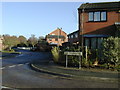
The Tyleshades / Tadburn Rd Junction Dec.2006
This is part of a housing estate built in the early 1980s on the site of the former Wills nurseries.
Image: © Patrick Pavey
Taken: 3 Dec 2006
0.10 miles
4
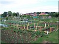
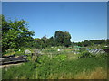
Romsey Town Council Allotments
The housing in the background is on the far side of the Romsey to Southampton railway line
Image: © David Martin
Taken: 12 Jun 2010
0.17 miles
5
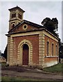
Romsey Nonconformist Cemetery Chapel
Grade 2 listed building erected in 1850.
Image: © Michael FORD
Taken: Unknown
0.18 miles
6
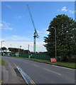
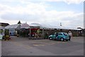
Crane towers over a Botley Road construction site in Romsey
Viewed at the end of May 2015. The site was formerly a garden centre.
Image: © Jaggery
Taken: 31 May 2015
0.19 miles
8
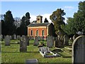
Cemetery Chapel, Romsey
This attractive Nonconformist chapel was built in 1850. Like the Anglican chapel this is now used for heritage and architectural salvcage storage.
Image: © Rosemary Oakeshott
Taken: 9 Dec 2007
0.19 miles
9
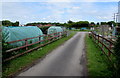
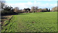
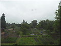
Path into Romsey Town Council Allotments
From the A27 Southampton Road at the southern edge of Romsey.
Image: © Jaggery
Taken: 31 May 2015
0.20 miles