IMAGES TAKEN NEAR TO
Hatt Hill, ROMSEY, SO51 0LH
Introduction
This page details the photographs taken nearby to Hatt Hill, SO51 0LH by members of the Geograph project.
The Geograph project started in 2005 with the aim of publishing, organising and preserving representative images for every square kilometre of Great Britain, Ireland and the Isle of Man.

There are currently over 7.5m images from over14,400 individuals and you can help contribute to the project by visiting https://www.geograph.org.uk
Image Map
Images are licensed for reuse under creativecommons.org/licenses/by-sa/2.0
Notes
- Clicking on the map will re-center to the selected point.
- The higher the marker number, the further away the image location is from the centre of the postcode.
Image Listing (17 Images Found)
Images are licensed for reuse under creativecommons.org/licenses/by-sa/2.0
Image
Details
Distance
1

Old Direction Sign - Signpost by the B3084, Hatt Hill, Mottisfont parish
Circular - centre Oak leaf finial - 3 arms; by the B3084, in parish of Mottisfont (Test Valley District), Hatt Hill, Mottisfont, junction with Hatt Lane.
To be surveyed
Milestone Society National ID: HA_SU3126
Image: © Milestone Society
Taken: Unknown
0.02 miles
3
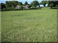
View from Hatt Hill
Having climbed through the field to the top of the hill you can see the patchwork of fields below us.
Image: © Gillian Thomas
Taken: 26 Apr 2007
0.17 miles
4
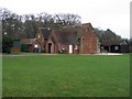
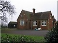
Mottisfont Village Hall and scout hut
This is the back of the old school, which has been converted into a village hall. The scout hut can be seen on the right.
Image: © Rosemary Oakeshott
Taken: 7 Feb 2008
0.18 miles
6
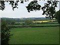
Footpath at Dunbridge leading to Hatt Hill
This footpath has crossed the railway line and leads up through the field opposite. A quick detour to the right brings you into the village of Dunbridge.
Image: © Gillian Thomas
Taken: 26 Apr 2007
0.18 miles
8
Mottisfont Village Hall
The old school, which was closed in about 1980, has been converted into a village hall. Local primary school aged children now have to go to Lockerley, Awbridge or further afield.
Image: © Rosemary Oakeshott
Taken: 7 Feb 2008
0.18 miles
9
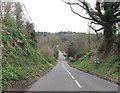
B3084 downhill towards Dunbridge
South of Bengers Lane
Image: © John Firth
Taken: 2 Apr 2014
0.18 miles
10
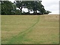
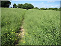
Footpath, Hatt Hill
The footpath takes walkers to Mottisfont.
Image: © Maigheach-gheal
Taken: 20 Jul 2009
0.20 miles