IMAGES TAKEN NEAR TO
Leigh Road, EASTLEIGH, SO50 9PD
Introduction
This page details the photographs taken nearby to Leigh Road, SO50 9PD by members of the Geograph project.
The Geograph project started in 2005 with the aim of publishing, organising and preserving representative images for every square kilometre of Great Britain, Ireland and the Isle of Man.

There are currently over 7.5m images from over14,400 individuals and you can help contribute to the project by visiting https://www.geograph.org.uk
Image Map
Images are licensed for reuse under creativecommons.org/licenses/by-sa/2.0
Notes
- Clicking on the map will re-center to the selected point.
- The higher the marker number, the further away the image location is from the centre of the postcode.
Image Listing (81 Images Found)
Images are licensed for reuse under creativecommons.org/licenses/by-sa/2.0
Image
Details
Distance
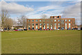
1
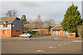
Home Farm, Kornwestheim Way, Eastleigh
Originally farm buildings around a courtyard, these have been converted to offices.
Image: © Peter Facey
Taken: 14 Feb 2009
0.01 miles
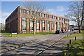
2
Fleming Court Business Centre, Kornwestheim Way
Image: © Peter Facey
Taken: 13 Feb 2009
0.03 miles
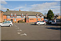
3

Eastleigh Borough Council offices, Kornwestheim Way
Eastleigh was twinned with the German town of Kornwestheim in 1978. See http://www.eastleigh.gov.uk/
Image: © Peter Facey
Taken: 13 Feb 2009
0.04 miles
4
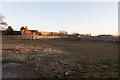
Development site on east side of Kornwestheim Way
Formerly Image . The council moved from here to a more central location on the corner of Romsey Road and Station Hill.
Image: © Peter Facey
Taken: 29 Dec 2016
0.05 miles
5
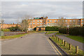
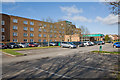
Holiday Inn, Eastleigh
The rear of the hotel, seen from Kornwestheim Way. The pedestrian entrance through the hedge at right is to the pavilion and bowling greens.
Image: © Peter Facey
Taken: 14 Feb 2009
0.06 miles
6
Holiday Inn, Passfield Avenue, Eastleigh
Image: © Peter Facey
Taken: 13 Feb 2009
0.06 miles
7
Holiday Inn
As with many of the hotels in this chain, the hotel is very close to main roads. in the case next to the A335 and only a few hundred metres from Junction 13 of the M3.
Image: © Nigel Mykura
Taken: 23 Dec 2012
0.06 miles
8
Eastleigh Borough Council office, Kornwestheim Way
Eastleigh was twinned with the French town of Villeneuve-Saint-Georges in 1964, see http://www.eastleigh.gov.uk/ . The short private road running across along the left side of this building is named Villeneuve St. Georges Way. Eastleigh was twinned with the German town of Kornwestheim in 1978.
Image: © Peter Facey
Taken: 13 Feb 2009
0.07 miles
9
Eastleigh Borough Council offices
Seen looking across Fleming Park playing fields.
Image: © Peter Facey
Taken: 13 Feb 2009
0.07 miles
10
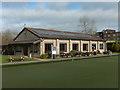
Parkside and Fleming Park Bowling Club
This fine facility, with its artificial all weather bowling green, is home to two bowling clubs - Parkside and Fleming Park. The former was created from the bowling section of the Pirelli Cables Social & Sports Club, relocated here in 2004. Fleming Park Club was established in 1937 and moved to this site in 1980. The clubhouse incorporates a bar and kitchen.
Image: © Stephen McKay
Taken: 4 Feb 2020
0.07 miles