IMAGES TAKEN NEAR TO
Main Road, EASTLEIGH, SO50 7HG
Introduction
This page details the photographs taken nearby to Main Road, SO50 7HG by members of the Geograph project.
The Geograph project started in 2005 with the aim of publishing, organising and preserving representative images for every square kilometre of Great Britain, Ireland and the Isle of Man.

There are currently over 7.5m images from over14,400 individuals and you can help contribute to the project by visiting https://www.geograph.org.uk
Image Map
Images are licensed for reuse under creativecommons.org/licenses/by-sa/2.0
Notes
- Clicking on the map will re-center to the selected point.
- The higher the marker number, the further away the image location is from the centre of the postcode.
Image Listing (39 Images Found)
Images are licensed for reuse under creativecommons.org/licenses/by-sa/2.0
Image
Details
Distance
1
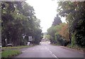
B3354 north of Fishers Pond
Fishers Pond road junction ahead
Image: © John Firth
Taken: 18 Sep 2013
0.01 miles
3
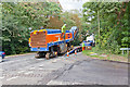
Road Planing machine being loaded
The machine, operated by http://www.tarmac.co.uk/products_and_services/contracting/road_planing.aspx , has just finished planing about 30mm off the top of Hensting Lane (foreground right) in preparation for the laying of 45 mm of tarmac. The machine is made by Wirtgen and is possibly a W2100 or W2200 model. It has four independently-operated tracks, the height of each being hydraulically adjustable.
Image: © Peter Facey
Taken: 7 Oct 2011
0.02 miles
4
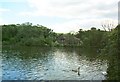
Fisher's Pond near Colden Common
This is the lake driving the mill from where this photo was taken (now a Brewers Fayre restaurant). Heron are frequently to be seen on the lake and there are always water fowl of one sort or another.
Image: © Alan Cooper
Taken: 7 Aug 2005
0.02 miles
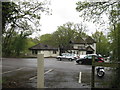
5
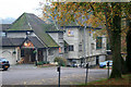
Fishers Pond
Large wooden-built pub on the western end of the eponymous Fishers Pond. The pub lies on the B3354.
Image: © David Lally
Taken: 14 Nov 2011
0.03 miles
6
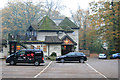
Fishers Pond
Large wooden-built pub on the western end of the eponymous Fishers Pond. The pub lies on the B3354.
Image: © David Lally
Taken: 14 Nov 2011
0.03 miles
7
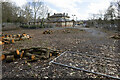
Development site at Fisher's Pond
Showing recently cut down trees making space for a care home to be built on this site.
Image: © Peter Facey
Taken: 17 Mar 2023
0.07 miles
8
Development site at Fisher's Pond
Showing recent removal of some trees to make way for a 68-bed care home on this site of the former Queen's Head pub.
Image: © Peter Facey
Taken: 17 Mar 2023
0.07 miles
9
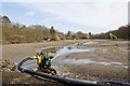
Fishers Pond during annual maintenance
This large pond (lake really) is part of Fishers Pond Fishery which supplies coarse fish to angling clubs. The pond is drained once a year to enable all fish in it to be taken out. It is then left empty for a while, possibly to control disease, before being allowed to refill naturally from the stream that flows through it. The JCB is removing mud from the pond. The spiky items along the centre line of the pond are aeration machines which normally float on the surface.
Image: © Peter Facey
Taken: 7 Mar 2008
0.07 miles
10
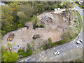
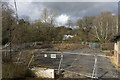
Development site at Fisher's Pond
Drone photo. Showing the site after the demolition of the former Queen's Head pub.
Image: © Peter Facey
Taken: 26 Apr 2023
0.08 miles