IMAGES TAKEN NEAR TO
Burnetts Lane, EASTLEIGH, SO50 7DG
Introduction
This page details the photographs taken nearby to Burnetts Lane, SO50 7DG by members of the Geograph project.
The Geograph project started in 2005 with the aim of publishing, organising and preserving representative images for every square kilometre of Great Britain, Ireland and the Isle of Man.

There are currently over 7.5m images from over14,400 individuals and you can help contribute to the project by visiting https://www.geograph.org.uk
Image Map
Images are licensed for reuse under creativecommons.org/licenses/by-sa/2.0
Notes
- Clicking on the map will re-center to the selected point.
- The higher the marker number, the further away the image location is from the centre of the postcode.
Image Listing (26 Images Found)
Images are licensed for reuse under creativecommons.org/licenses/by-sa/2.0
Image
Details
Distance
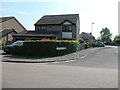
1
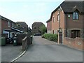
Barley Fields, Horton Heath
A development of named not numbered houses on a private road, off Burnetts Lane.
Image: © Christine Johnstone
Taken: 23 Apr 2022
0.03 miles
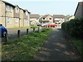
2
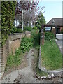
Public footpath, St Andrews Park, Horton Heath
With a warning about CCTV, but not about the nettles!
Image: © Christine Johnstone
Taken: 23 Apr 2022
0.05 miles
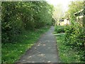
4
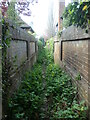
Mind the nettles in Horton Heath
The west end of the southern of two public footpaths linking Botley Road and Burnetts Lane. Not to be walked in shorts or sandals.
Image: © Christine Johnstone
Taken: 23 Apr 2022
0.06 miles
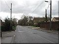
5
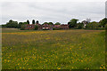
Houses at southwest corner of Horton Heath
Off Burnetts Lane. Seen looking across the lush fields of Chalcroft Farm, used for rearing beef cattle for Owtons butchers.
Image: © Peter Facey
Taken: 25 May 2016
0.06 miles
6
Bryony Gardens and Meadowsweet Way
All the roads in this Horton Heath estate are named after flowers.
Image: © Christine Johnstone
Taken: 23 Apr 2022
0.10 miles
7
Footpath along Burnetts Lane, Horton Heath
Separated from the road by a line of trees, with paths going off into the estate served by Meadowsweet Way.
Image: © Christine Johnstone
Taken: 23 Apr 2022
0.10 miles
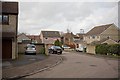
9
Junction of Campion Close and Meadowsweet Way
All the streets in this estate in the village of Horton Heath are named after flowers.
Image: © Christine Johnstone
Taken: 23 Apr 2022
0.13 miles
10
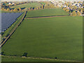
Site of proposed The Upper Acre housing development
Aerial. The part of the field in the lower area of this photo will become part of The Upper Acre housing development. Beyond, but before the hedge, a sports field is planned (https://www.geograph.org.uk/photo/7353988). Beyond that hedge, a primary school is planned (https://www.geograph.org.uk/photo/7353987).
Image: © Peter Facey
Taken: 1 Dec 2022
0.15 miles