IMAGES TAKEN NEAR TO
Rogers Road, EASTLEIGH, SO50 6DZ
Introduction
This page details the photographs taken nearby to Rogers Road, SO50 6DZ by members of the Geograph project.
The Geograph project started in 2005 with the aim of publishing, organising and preserving representative images for every square kilometre of Great Britain, Ireland and the Isle of Man.

There are currently over 7.5m images from over14,400 individuals and you can help contribute to the project by visiting https://www.geograph.org.uk
Image Map
Images are licensed for reuse under creativecommons.org/licenses/by-sa/2.0
Notes
- Clicking on the map will re-center to the selected point.
- The higher the marker number, the further away the image location is from the centre of the postcode.
Image Listing (33 Images Found)
Images are licensed for reuse under creativecommons.org/licenses/by-sa/2.0
Image
Details
Distance
1
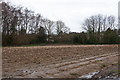
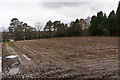
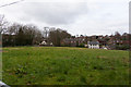
Field south of Bishopstoke Cemetery
This shows the southwestern part of the field that would become an extension of Bishopstoke Cemetery should the proposed development gain planning permission.
Image: © Peter Facey
Taken: 4 Mar 2014
0.05 miles
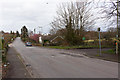
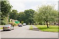
2
Near Bishopstoke
Looking towards Bishopstoke.
Image: © T Eyre
Taken: 21 Mar 2016
0.08 miles
3
Field between Stoke Common and Stoke Park Wood
There is also a small car park over the brow of the hill.
Image: © Peter Facey
Taken: 26 Jun 2022
0.08 miles
4
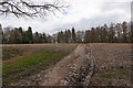
Footpath and field south of Bishopstoke Cemetery
This is the field that would be made available as an extension to the cemetery, should the proposed development be approved. The footpath affords access to Stoke Park Wood which is Forestry Commission property.
Image: © Peter Facey
Taken: 4 Mar 2014
0.09 miles
5
Field south of Bishopstoke Cemetery
This shows the northern half of the field that would be made available as an extension to Bishopstoke Cemetery, should the proposed development gain planning permission. The existing cemetery is beyond the conifers seen at the right of this photo.
[elevated camera position]
Image: © Peter Facey
Taken: 4 Mar 2014
0.10 miles
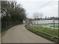
6
Private road to Stoke Park Farm
This road (the one going off to the right) would become the main entrance and exit for the 60 houses proposed to be built. The road in foreground is Stoke Common Road.
Image: © Peter Facey
Taken: 4 Mar 2014
0.10 miles
7
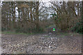
Footpath entering Stoke Park Wood
The wood is owned by the Forestry Commission. This shows the southeastern edge of the field that would be made available as an extension to Bishopstoke Cemetery, should the proposed development gain planning permission.
Image: © Peter Facey
Taken: 4 Mar 2014
0.10 miles
8
Field and private road to Stoke Park Farm
Also a bridleway and the access to Bishopstoke Cemetery.
Image: © Peter Facey
Taken: 4 Mar 2014
0.10 miles
9
Field west of Bishopstoke Cemetery
This field would become open space, with a new bridleway going through it, if the proposed development went ahead.
Image: © Peter Facey
Taken: 4 Mar 2014
0.10 miles
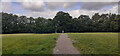
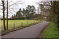
10
Eastern end of Stoke Park Road, Bishopstoke
The road stops here. Stoke Park Wood beyond.
Image: © Peter Facey
Taken: 23 Jul 2008
0.12 miles