IMAGES TAKEN NEAR TO
Sandy Down, LYMINGTON, SO41 8PL
Introduction
This page details the photographs taken nearby to Sandy Down, SO41 8PL by members of the Geograph project.
The Geograph project started in 2005 with the aim of publishing, organising and preserving representative images for every square kilometre of Great Britain, Ireland and the Isle of Man.

There are currently over 7.5m images from over14,400 individuals and you can help contribute to the project by visiting https://www.geograph.org.uk
Image Map
Images are licensed for reuse under creativecommons.org/licenses/by-sa/2.0
Notes
- Clicking on the map will re-center to the selected point.
- The higher the marker number, the further away the image location is from the centre of the postcode.
Image Listing (13 Images Found)
Images are licensed for reuse under creativecommons.org/licenses/by-sa/2.0
Image
Details
Distance
1
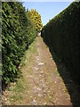
Footpath between the Houses at Sandy Down
This part of the footpath goes between the neatly cut conifer hedges of two houses in Sandy Down.
Image: © Gillian Thomas
Taken: 5 Apr 2007
0.02 miles
2
Footpath at Sandy Down
This footpath leads between the two lanes at Sandy Down.
Image: © Gillian Thomas
Taken: 5 Apr 2007
0.05 miles
3
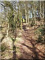
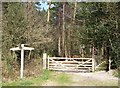
Bridleway junction at the southern edge of Roydon Woods, New Forest
The gateway leads north into the Roydon Woods nature reserve, the footpath south to the village of Sandy Down.
Image: © Jim Champion
Taken: 2 Oct 2005
0.07 miles
4
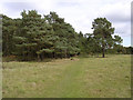
Southern edge of Roydon Woods, Sandy Down, New Forest
This bridleway leads through the southern part of Roydon Woods nature reserve, on the edge of Sandy Down.
Image: © Jim Champion
Taken: 2 Oct 2005
0.08 miles
5
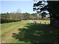
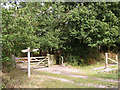
The Southern Edge of Roydon Wood Nature Reserve
Leaving Sandy Down we pass through a kissing gate and head towards Fluder's Clump at the Southern end of Roydon Woods.
Image: © Gillian Thomas
Taken: 5 Apr 2007
0.10 miles
6
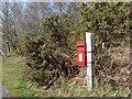
Boldre: postbox № SO41 143, Sandy Down
One of two postboxes serving the outspread hamlet of Sandy Down. Both are Elizabeth II-reign boxes clasped to a wooden post and both are emptied finally at 4:30pm on weekdays. This one, though, is emptied at 10am on Saturdays, 90 minutes later than the other one.
Image: © Chris Downer
Taken: 25 Mar 2012
0.13 miles
7
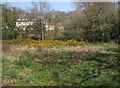
Sandy Down
From the footpath in the field south of Sandy Down.
Image: © Gillian Thomas
Taken: 5 Apr 2007
0.15 miles
8
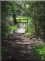
Bridge and Stile at Sandy Down
This bridge crosses a small brook that feeds into the Lymington River.
Image: © Gillian Thomas
Taken: 5 Apr 2007
0.15 miles
9
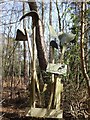
Beaters at the entrance to Roydon Woods
These beaters are placed on the boundary footpaths of the Roydon Woods Nature Reserve in case of fire.
Image: © Gillian Thomas
Taken: 5 Apr 2007
0.15 miles
10
Bridleway Junction at Sandy Down
Through the gate for Fluder's Clump. The other directions take you back to Sandy Down Lanes.
Image: © Gillian Thomas
Taken: 5 Apr 2007
0.16 miles