IMAGES TAKEN NEAR TO
Efford Way, LYMINGTON, SO41 8BX
Introduction
This page details the photographs taken nearby to Efford Way, SO41 8BX by members of the Geograph project.
The Geograph project started in 2005 with the aim of publishing, organising and preserving representative images for every square kilometre of Great Britain, Ireland and the Isle of Man.

There are currently over 7.5m images from over14,400 individuals and you can help contribute to the project by visiting https://www.geograph.org.uk
Image Map
Images are licensed for reuse under creativecommons.org/licenses/by-sa/2.0
Notes
- Clicking on the map will re-center to the selected point.
- The higher the marker number, the further away the image location is from the centre of the postcode.
Image Listing (49 Images Found)
Images are licensed for reuse under creativecommons.org/licenses/by-sa/2.0
Image
Details
Distance
1
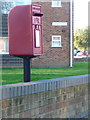
Lymington: postbox № SO41 17, Efford Way
This Elizabeth II-reign postbox is mounted on a metal post which is actually set behind the wall of the grounds of Corbin Court, a block of flats.
Image: © Chris Downer
Taken: 11 Jan 2014
0.04 miles
4
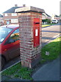
Lymington: postbox № SO41 72, Corbin Road
This George VI-reign postbox is set into a brick pillar and serves a council housing estate on the western outskirts of town.
Image: © Chris Downer
Taken: 11 Jan 2014
0.12 miles
7
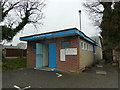
St Mark's Church Centre, Pennington: February 2013
Image: © Basher Eyre
Taken: 9 Feb 2013
0.14 miles
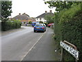
8
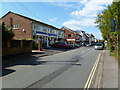
Pennington, shopping centre
North Street, in the traditional village centre. Shops include beauty salon, florist, butcher, hair salon, cafe, homecare, mobility and pharmacy.
Image: © Mike Faherty
Taken: 4 Sep 2011
0.15 miles
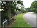
9
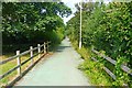
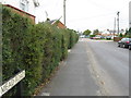
Cycle and Footpath at Upper Pennington
This fairly new pathway has a good, hard surface, and is coloured green to show off its credentials.
Image: © mike smith
Taken: 1 Aug 2013
0.16 miles
10

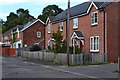
The IRC House, Pennington
This building, now offices, would appear to be a former chapel.
Update July 2019 - a site visitor writes:
"This is a former school, built in the late 1800's as extra classrooms for the main school built in 1852, the red faced building with white surround windows that is some 100 mtrs further up the road in the village square (although the school boundary is actually triangular. I know as I went to both as a child (1955-1959)."
Image: © mike smith
Taken: 10 Dec 2013
0.17 miles