IMAGES TAKEN NEAR TO
Flexford Lane, LYMINGTON, SO41 6DN
Introduction
This page details the photographs taken nearby to Flexford Lane, SO41 6DN by members of the Geograph project.
The Geograph project started in 2005 with the aim of publishing, organising and preserving representative images for every square kilometre of Great Britain, Ireland and the Isle of Man.

There are currently over 7.5m images from over14,400 individuals and you can help contribute to the project by visiting https://www.geograph.org.uk
Image Map
Images are licensed for reuse under creativecommons.org/licenses/by-sa/2.0
Notes
- Clicking on the map will re-center to the selected point.
- The higher the marker number, the further away the image location is from the centre of the postcode.
Image Listing (14 Images Found)
Images are licensed for reuse under creativecommons.org/licenses/by-sa/2.0
Image
Details
Distance
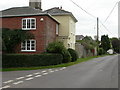
1
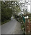
Flexford Lane near Sway
Looking east down the lane from Cottage Garden Boarding cattery and doggery.
Image: © Peter Beaven
Taken: 13 Apr 2007
0.01 miles
2
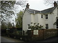
Granville House, Flexford Lane, Sway
Cattery and Doggery
Image: © Peter Beaven
Taken: 13 Apr 2007
0.03 miles
3
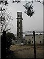
Evening sunlight in Flexford Lane
Looking across the lane to Peterson's Tower in Sway.
Image: © Peter Beaven
Taken: 13 Apr 2005
0.05 miles
4
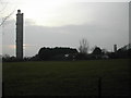
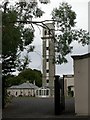
The two towers in Sway
The smaller tower to the north is alleged to be a sucker growth of the taller one! Others say it was built as a prototype for the full-grown tower.
Image: © Peter Beaven
Taken: 13 Apr 2007
0.11 miles
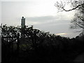
5
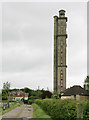
The smaller tower in Sway
The smaller tower and its surroundings near Arnewood Court are in the process of refurbishment.
Image: © Peter Beaven
Taken: 13 Apr 2007
0.13 miles
6
Arnewood, Tower Hall
At the junction of Barrows and Flexford Lanes; a trial concrete tower before Peterson's Tower, to the South, was built. Hoardings outside advertise the site as business and storage facilities. English Heritage-listed, http://www.imagesofengland.org.uk/Details/default.aspx?pid=2&id=144433
Image: © Mike Faherty
Taken: 9 Sep 2009
0.15 miles
7
Sway Tower
The tower was built by eccentric Yorkshireman Andrew Peterson in 1879. It is 218 feet tall and built of unreinforced concrete. There are nearly 400 steps in the spiral staircase seen on the left side in the photo. More information at http://homepage.ntlworld.com/follies/swaytxt.html
Image: © Peter Facey
Taken: 22 May 2006
0.17 miles
8
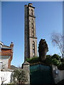
Sway: Sway Tower
A Victorian folly of some 218 feet in height, it was for a time a hotel but is now a private residence. This is the view from very close quarters; from a little farther away the view is marred by telephone wires.
Image: © Chris Downer
Taken: 12 Feb 2011
0.17 miles
9
Arnewood, Drumduan Farm
At the southern side of the junction of Barrows and Flexford Lanes, converted farmhouse, once the property of Andrew Peterson, builder of the Sway Towers Image The house is listed by English Heritage, http://www.imagesofengland.org.uk/Details/default.aspx?pid=2&id=144434
Image: © Mike Faherty
Taken: 9 Sep 2009
0.18 miles
10
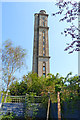
Sway Tower
Sway Tower is 66 metres (200 ft) tall and is a Grade II listed building. It is also known as "Peterson's Folly". Built by Andrew Thomas Turton Peterson on his private estate from 1879–1885. It is constructed entirely out of concrete, with only the windows having iron supports. It remains the tallest non-reinforced concrete structure in the world.
Image: © mike smith
Taken: 10 Aug 2012
0.18 miles