IMAGES TAKEN NEAR TO
Kings Lane, LYMINGTON, SO41 6BQ
Introduction
This page details the photographs taken nearby to Kings Lane, SO41 6BQ by members of the Geograph project.
The Geograph project started in 2005 with the aim of publishing, organising and preserving representative images for every square kilometre of Great Britain, Ireland and the Isle of Man.

There are currently over 7.5m images from over14,400 individuals and you can help contribute to the project by visiting https://www.geograph.org.uk
Image Map
Images are licensed for reuse under creativecommons.org/licenses/by-sa/2.0
Notes
- Clicking on the map will re-center to the selected point.
- The higher the marker number, the further away the image location is from the centre of the postcode.
Image Listing (11 Images Found)
Images are licensed for reuse under creativecommons.org/licenses/by-sa/2.0
Image
Details
Distance
1
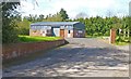
Entrance to New Forest Growers Ltd
New Forest Growers, according to their website, are "a non-profit making friendly society which sources and supplies all types of commercial horticultural products for use by its members and customers".
Image: © mike smith
Taken: 29 Apr 2013
0.15 miles
2
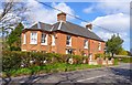
Rose Cottage at Mount Pleasant
This would appear to be two semi-detached homes, on Pitmore Lane.
Image: © mike smith
Taken: 29 Apr 2013
0.16 miles
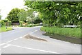
3
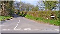
Kings Lane, Mount Pleasant
This is the junction of Kings Lane with Pitmore Lane.
Image: © mike smith
Taken: 29 Apr 2013
0.16 miles
4
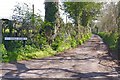
Kings Hyde at Mount Pleasant
This narrow lane connects Pitmore Lane with Mount Pleasant Lane.
Image: © mike smith
Taken: 29 Apr 2013
0.17 miles
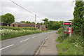
5
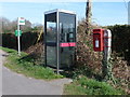
Sway: postbox № SO41 147 and phone, Pitmore Lane
An Elizabeth II-reign postbox, clasped to its own wooden post, stands alongside a modern telephone box. The postbox is emptied finally at 5:15pm on weekdays and at 7:45am on Saturdays.
Image: © Chris Downer
Taken: 25 Mar 2012
0.18 miles
6
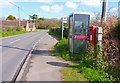
Pitmore Lane, Mount Pleasant
There are hardly any homes here, but this point sports a bus stop, phone box and letter box.
Image: © mike smith
Taken: 29 Apr 2013
0.18 miles
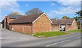
8
Pitmore Lane north of its junction with Kings Lane
Mount Pleasant Lane joins Pitmore Lane just before the bend opposite the Farm buildings.
Image: © Peter Facey
Taken: 22 May 2006
0.18 miles
9
Junction of Mount Pleasant Lane and Pitmore Lane
This is a staggered cross roads. The road opposite on left is Pauls Lane.
Image: © Peter Facey
Taken: 22 May 2006
0.18 miles
10
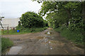
Mill Lane, Mount Pleasant
At the Pitmore Lane end, Mill Lane is tarmac, but it soon becomes like this. The lane provides access to fields on either side in which horses are kept. It is also a bridleway.
Image: © Peter Facey
Taken: 22 May 2006
0.24 miles