IMAGES TAKEN NEAR TO
SO4 0HL
Introduction
This page details the photographs taken nearby to SO4 0HL by members of the Geograph project.
The Geograph project started in 2005 with the aim of publishing, organising and preserving representative images for every square kilometre of Great Britain, Ireland and the Isle of Man.

There are currently over 7.5m images from over14,400 individuals and you can help contribute to the project by visiting https://www.geograph.org.uk
Image Map
Images are licensed for reuse under creativecommons.org/licenses/by-sa/2.0
Notes
- Clicking on the map will re-center to the selected point.
- The higher the marker number, the further away the image location is from the centre of the postcode.
Image Listing (9 Images Found)
Images are licensed for reuse under creativecommons.org/licenses/by-sa/2.0
Image
Details
Distance
1
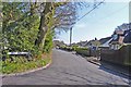
Sky End Lane
This residential road has the wonderful name of Sky End Lane. Around the corner is a large house called Sky End.
Image: © mike smith
Taken: 13 Apr 2012
0.01 miles
2
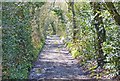
Gravel Track to Leagreen
This dirt track is a continuation of Vicarage Lane, and leads to Leagreen on the main A337 Lymington to Christchurch road.
Image: © mike smith
Taken: 13 Apr 2012
0.06 miles
3
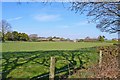
Field at Hordle
This would have been part of a farm at one time.
Whether it is still part of the nearby Yeatton Farm is unclear.
Image: © mike smith
Taken: 13 Apr 2012
0.06 miles
4
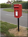
Hordle: postbox № SO41 190, Pegasus Avenue
An ordinary Elizabeth II-reign postbox close to the junction with the more major Vicarage Lane, which we see in the background.
Image: © Chris Downer
Taken: 26 Aug 2013
0.09 miles
5
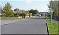
Pegasus Avenue
This is one of several residential roads in a rectangular development to the south of Hordle.
Image: © mike smith
Taken: 13 Apr 2012
0.12 miles
6
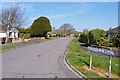
Berryfield Road
This is one of several residential roads in a rectangular development to the south of Hordle.
Image: © mike smith
Taken: 13 Apr 2012
0.12 miles
7
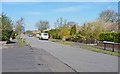
Longfield Road
This is one of several residential roads in a rectangular development to the south of Hordle.
Image: © mike smith
Taken: 13 Apr 2012
0.21 miles
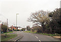
8
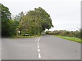
Stopples Lane
The view of the Stopples Lane junction with Hordle Lane, near Hordle village.
Image: © Gordon Griffiths
Taken: 30 Sep 2019
0.25 miles