IMAGES TAKEN NEAR TO
St. Davids Close, SOUTHAMPTON, SO40 2WA
Introduction
This page details the photographs taken nearby to St. Davids Close, SO40 2WA by members of the Geograph project.
The Geograph project started in 2005 with the aim of publishing, organising and preserving representative images for every square kilometre of Great Britain, Ireland and the Isle of Man.

There are currently over 7.5m images from over14,400 individuals and you can help contribute to the project by visiting https://www.geograph.org.uk
Image Map
Images are licensed for reuse under creativecommons.org/licenses/by-sa/2.0
Notes
- Clicking on the map will re-center to the selected point.
- The higher the marker number, the further away the image location is from the centre of the postcode.
Image Listing (22 Images Found)
Images are licensed for reuse under creativecommons.org/licenses/by-sa/2.0
Image
Details
Distance
1
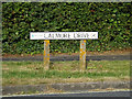
Calmore Drive sign
At the junction with Calmore Drive
Image: © Geographer
Taken: 27 Jun 2014
0.07 miles
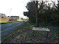
2
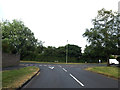
Calmore Drive, Calmore
At the junction Calmore Drive
Image: © Geographer
Taken: 27 Jun 2014
0.07 miles
3
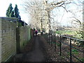
All weather public footpath alongside Calmore recreation ground
A footpath between the houses and the recreation ground with gaps in the railings to allow access to the playing field.
Image: © J W Parker
Taken: 2 Feb 2018
0.08 miles
4
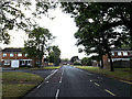
Calmore Drive, Calmore
At the junction with Tudor Close & Melrose Court
Image: © Geographer
Taken: 27 Jun 2014
0.09 miles
5
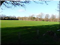
Calmore recreation ground
A field for sports and dog walking in Calmore close to the nearby dog activity trail
Image: © J W Parker
Taken: 2 Feb 2018
0.10 miles
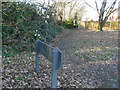
6
Richmond Close leading to Woodlodge sign
The sign alongside the footpath that used to lead to Woodlodge house that now leads to woodlodge close.
Image: © J W Parker
Taken: 2 Feb 2018
0.11 miles
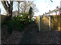
7
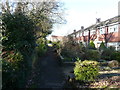
Footpath to Woodlodge Close
This footpath to Woodlodge Close used to be the boundary of the old Woodlodge house. It had an orchard, a small putting area, a tennis court and a little woodland in the 1930s. If the gate was left open the new forest ponies would come into the grounds and eat all the shrubs; encouraging them out was quite a task for the Parker boys.
Image: © J W Parker
Taken: 2 Feb 2018
0.12 miles
8

Hard all weather path alongside Calmore recreation ground
An all weather footpath that runs along Calmore recreation ground.
Image: © J W Parker
Taken: 2 Feb 2018
0.12 miles
9
Richmond Close leading to Woodlodge
The houses in Richmond close face the old boundary line of the Woodlodge site.
Image: © J W Parker
Taken: 2 Feb 2018
0.13 miles
10
Richmond Close leading to Woodlodge Close
Richmond Close which runs alongside the boundary of the old Woodlodge house known as the big house in the 1930s in Calmore. Now the grounds are Woodlodge Close.
Image: © J W Parker
Taken: 2 Feb 2018
0.15 miles